(ISSN 2300-1496)
(ISSN 2300-1496)
(ISSN 2300-1496)
(ISSN 2300-1496)

(ISSN 2300-1496)

(ISSN 2300-1496)
(ISSN 2300-1496)
The first issue, No. 1
The second issue, No. 2
The first issue, No. 1 (2022)
Justyna Wójcik-Leń 
![]() , Klaudia Maciąg
, Klaudia Maciąg ![]() , Michał Maciąg
, Michał Maciąg ![]() , Adrian Moskal
, Adrian Moskal ![]() , Kornelia Moskal
, Kornelia Moskal ![]() , Przemysław Leń
, Przemysław Leń ![]()
Analysis of the implementation of land consolidation and exchange in the villages of the Leżajsk district
Corresponding author
DOI: http://dx.doi.org/10.15576/GLL/2022.1.7
Rural areas in Poland have a diversified spatial structure. The spatial structure of rural areas is improved by the procedures of land consolidation and exchange, aimed at creating more favourable management conditions in agriculture and forestry by developing the area structure of agricultural holdings, forests and forest lands, as well as rational shaping of land layouts and adjusting real estate boundaries to a system of land reclamation devices, roads and terrain. The Leżajsk district covers an area of 58,372 ha, including 40 cadastral precincts. So far, land consolidation has been performed in 29 villages, covering 46 113 ha, which is 79.0% of the total area of the district. Land consolidation in the Leżajsk district was carried out at various periods due to the changing legal regulations. The paper aims to present a chronological analysis of the land consolidation works conducted in the villages of the Leżajsk district, located in the Podkarpackie Voivodeship in 1945–2013, along with anticipated and implemented land consolidation works in the years 2014–2020.
Keywords: land consolidation • rural areas • land use • agricultural production space
Monika Maria Siejka ![]() , Konrad Słomiany, Mariusz Górak
, Konrad Słomiany, Mariusz Górak
Analysis of the level of prices and number of transactions, and their dynamics on the housing real estate market – a case study in Katowice
Corresponding author
DOI: http://dx.doi.org/10.15576/GLL/2022.1.25
The development of the real estate market necessitates a continuous need for analyses regarding the distribution of the number of transactions and level of transaction prices of real estate. This information is important for many market participants, such as investors, property owners, creditors, developers, as well as state and local government administration (for fiscal reasons). Transaction price data are systematically collected by administration units and are generally available to citizens. However, prices themselves do not provide sufficient information for the average user. Only when combined with geospatial data, they constitute complete and user-expected information. This publication analyses the distribution of unit transaction prices and the number of housing real estate transactions in the city of Katowice. A publicly available QGIS programme was used for the analysis. The results of the research proved the usefulness of the methodology used. Using the Voronoi diagram, the spatial distribution of the number of transactions in the studied area was presented. Using the methods of graphical data visualisation, the distribution of transaction prices in individual plats and the change in the distribution of transaction prices depending on the distance from the city centre were presented. In the case of the number of concluded transactions, plat 2 dominates, both on the primary and secondary market. In addition, in both cases, 2019 was the year with the most activity. Whereas, the highest transaction prices were recorded in 2020. In secondary trading, it was plat 14, and in primary trading – plat 3. The last year of the analysis is the period in which there was a large jump in prices, with a decrease in the number of transactions.
Keywords: GIS • QGIS • Voronoi diagram • real estate market analysis • spatial analysis
Justyna Wójcik-Leń ![]()
Characterisation of land unsuitable for agriculture and possibilities of its development in rural areas
Corresponding author
DOI: http://dx.doi.org/10.15576/GLL/2022.1.41
Rural areas are influenced by many natural, social and economic factors. The historical conditions of social development, such as the rate of population growth, low yields and chronic food shortages, leading to the development of less useful areas with low production potential for agricultural purposes, have had an impact on the current state of rural areas. In addition, there is considerable fragmentation of agricultural land in these areas and a focus on production to meet farmers’ own needs. Scientific literature comprises many proposals to define agriculturally unsuitable land in relation to the marginal, problem or abandoned land. This depends mainly on the research discipline, the authors and the approach to the issue under discussion. This paper aims to review the terminology and characterisation of land unsuitable for agriculture in Poland and selected European and Asian countries. Moreover, studies have been conducted into the reasons for the expansion of these areas and the ways of their development (e.g., performing forestry functions, growing crops for energy purposes, promoting tourism and recreation as well as pedestrian or hippie bicycle routes, creating ecological areas, terracing the slopes), which in the result is the main priority of agricultural development and improvement of the spatial structure of farms. Realising the specific functions the presented land is intended for should determine the direction of changes in their alternative development. All solutions for the development of these areas should be managed with a necessary consideration of social, economic and environmental aspects.
Keywords: land unsuitable for agriculture • marginal land • problem areas • abandoned land • rural areas • spatial structure of farms
Methods of revaluation of former geodetic measurement networks
Corresponding author
DOI: http://dx.doi.org/10.15576/GLL/2022.1.61
Geodetic field measurements carried out in the past when establishing and updating the land registers were based directly on geodetic measurement networks. The accuracy parameters of these networks are lower compared to modern geodetic measurement networks. Currently, archival materials of the National Geodetic and Cartographic Resources are used in surveying works on real estate. The following paper presents and evaluates three methods of improving the accuracy parameters of former registry and measurement networks. The first method (I) involves transforming the coordinates of former network points into a current coordinate system based on the coordinates of the adjustment points. The second method (II) is based on a strict alignment of a geodetic network together with additional measurement of selected points to strengthen the network. The third method (III) consists of an inventory and measurement of all existing points of former geodetic networks and a strict alignment of the network to determine the coordinates of destroyed points. The effectiveness of the revaluation methods of former networks was assessed on the basis of experimental studies using data from test objects. Satisfactory results of the improvement of accuracy parameters of the network were achieved by the method (I) in those cases in which the ratio of the number of adjustment points to the total number of tested points was approx. 1/3. Similarly, for the method (III), satisfactory results can be achieved if approx. 30% of network points are used as additional control points. However, in the method (II), good results can be achieved if the percentage of searched-out points used as control points is only about 10% of all network points. Examining the complex surveying works (fieldwork and inhouse studies) has shown that both the method (I) and the method (II) of revaluation of geodetic networks have similar efficiency.
Keywords: modernisation of land and building registry • cadastre • spatial data quality
Bogusława Kwoczyńska ![]()
Analysis of land use change in selected metropolitan areas in Poland based on remote sensing data
Corresponding author
DOI: http://dx.doi.org/10.15576/GLL/2022.1.73
The aim of the study was to diagnose the main trends of changes in land cover in selected communes of Polish metropolitan areas. Detailed studies were conducted in deliberately selected housing estates located in the core of metropolitan area (at least one housing estate) and communes located directly at the border of cities and located on the outskirts of metropolitan areas. The examined communes also differed in the quality of natural conditions of agricultural production. The study used LANDSAT 5 TM and RapidEye satellite images from three limited-time registrations (1996/1999, 2011, 2016/2017). On the basis of remote sensing data, changes in land use were specified by presenting them in a graphic form as compilation of numerical maps. The analyses were performed on processed images (colour compositions), which were subjected to supervised classification using the maximum-likelihood technique. The quality control of supervised classification showed accuracy of 89.3% for LANDSAT 5 TM scene analyses and 91.8% for RapidEye images. Kappa coefficient for the discussed classification was: 0.84 (LANDSAT TM) and 0.89 (Rapid Eye). The results obtained for individual metropolitan areas allow to identify the directions of changes (Land Use Change Cover) taking place in them, with consideration to specificity of each of them.
Keywords: land cover • metropolitan area • satellite data
Comparison of the publicly available digital terrain model provided by the head office of geodesy and cartography with gnss satellite measurement
Corresponding author
DOI: http://dx.doi.org/10.15576/GLL/2022.1.103
Due to the ever-better accessibility of the digital terrain model (DTM), it is enjoying growing popularity as a source of information about the surrounding world. It became even more approachable when DTM data covering the whole of Poland was made available free of charge on the Geoportal website. The GRID with a resolution of 1 meter per 1 meter covers virtually the entire country. The data on the Geoportal does not only refer to the measurements processed into a grid of squares, but also includes measurement data. They can be accessed through a systematic division into section sheets in the 1992 system. The paper presents research on assessing the accuracy of these publicly available data, compared to measurements obtained with the GNSS observations. The analysis involved data directly from the measurement device, not yet processed into a grid of squares. As part of the research, the height of 3 objects was compared. It was decided to measure the terrain profiles. To get as close as possible to the source data provided at the Geoportal website, the selected points of profiles previously identified in the point cloud were measured. This approach freed the final results from the need for height interpolation for the data selected for analysis. As result, the potential source of errors in such an approach was eliminated. Although during a classical profile measurement with this technology the selection of points would certainly be different, for research purposes this approach seems optimal. For this reason, in addition to the expected deviations resulting from the height differences of the tested points, deviations from the data from the point cloud of the XY coordinates, related to the adopted technology, are also presented.
Keywords: digital terrain model (DTM) • point cloud • DTM error • GNSS
Determination of the silting rate of thuringian dam reservoirs on the example of Dachwig and Ohra reservoirs
Corresponding author
DOI: http://dx.doi.org/10.15576/GLL/2022.1.117
The silting process of reservoirs limits their use. Predicting this process is important for economic reasons. The paper assesses the possibility of using the methods of forecasting the silting process developed in studies of small Polish reservoirs to determine this process in reservoirs in other geographical regions. This analysis covers the Dachwig and Ohra reservoirs, located in Thuringia, Germany. The forecast of silting was developed using the Gončarov formula according to the guidelines in force in Poland and following the empirical formula used to calculate the average annual silting. It allowed determining the rate of silting. Based on the results of calculations using the Gončarov formula, it was found that the degree of silting after 100 years of operation of the Dachwig and Ohra reservoirs will be 2.45% and 0.001%, respectively. The average annual silting rate calculated from these data was found to be lower than that calculated using the empirical formula. The limitation of the empirical formula is also the reason for obtaining higher values of the average annual silting degree, which was developed in studies of reservoirs with capacities smaller than 3.86 million m3. Thus, for the 2.1 million m3 Dachwig reservoir, a difference of 43% in results was obtained, while for the much larger 17.5 million m3 Ohra reservoir, results differing by as much as three times were obtained.
Keywords: silting degree • silting intensity • silting forecast
The second issue, No. 2 (2022)
Łukasz Byś ![]()
A contemporary method of activating manor complexes on the example of Pisary village
Corresponding author
DOI: http://dx.doi.org/10.15576/GLL/2022.2.7
In Poland, manor complexes are a reminder of the country’s history, identity and culture. Their activation is necessary to save them from being forgotten. The aim of the conceptual design presented in this paper is to determine the adaptability of the area at the former manor granary in the village of Pisary, located in the municipality of Zabierzów in the Małopolskie Voivodeship. The planned activities are meant to transform the area for agritourism purposes and make it
available to both visitors and residents of the municipality. The changes in the selected area over the centuries were traced with analytical methods involving field research. Based on the opportunities offered by the surrounding landscape parks, potential uses of the area were also identified. In addition, efforts were made to symbolically merge the manor estate, the structure of which had been upset by the land parcelling. As a result of the analyses, three main zones were delineated, namely the recreation, educational and service zones. The project includes an adaptation of historic buildings for agritourism purposes together with accompanying services.
In the conceptual design, the picturesque courtyard was developed into a multifunctional centre at a historic site with accompanying infrastructure. The terrain and natural conditions were utilised to create tourist attractions, providing active recreation. The centuries-old park, for example, has been made more suitable for walking and admiring the local fauna and flora. These interventions have enhanced the high landscape values of the site, ensuring that it meets the needs of contemporary visitors. This project shows how an attractive and welcoming facility can be created with little interference and in respect of the history of the site. This project is an example of how to use natural, geological, landscape and historical values to design an interesting point on the tourist map of the municipality.
Keywords: Pisary • adaptation • manor complex activation • tourism
Małgorzata Frosik ![]()
Undeveloped non-investment land properties versus designated for single-family housing, as illustrated with the example of the Niepołomice municipality
Corresponding author
DOI: http://dx.doi.org/10.15576/GLL/2022.2.19
The Niepołomice municipality is located approx. 25 km from the center of Kraków and directly adjoins the Kraków agglomeration from the south-east. Its natural boundaries are marked by the Vistula River and the Niepołomice Forest. The municipality of Niepołomice is highly attractive to investors, which is due, inter alia, to lower real estate prices compared to the neighboring city of Kraków (the capital of the voivodeship), the presence of an industrial zone that guarantees
numerous jobs, good transport connections with Kraków, and a substantial amount of green and recreational areas.
The market of undeveloped land in Niepołomice is dynamic and very diverse, but when the transactions are grouped according to their designated functional purpose in the local spatial development plan, certain trends characteristic of a given group of transactions can be observed. In the present study, we attempt to compare the market of undeveloped non-investment land properties (with intended land use in the local zoning plan defined as agricultural land, green areas, etc.) and those designated for the development of single-family housing, across the entire Niepołomice municipality, on the basis of transactions made in the local real estate market during the 2020–2021 period.
Keywords: real estate market • property prices • Niepołomice Municipality
Szczepan Budkowski ![]()
Regulations for unmanned aerial vehicle flights in poland and other european countries – an analysis of the applicable law
Corresponding author
DOI: http://dx.doi.org/10.15576/GLL/2022.2.27
In Poland, a growing interest in unmanned aerial vehicles has been observed in successive years. First and foremost, the development trend concerns operations with the use of unmanned aerial vehicles – i.e. drones – employed for sport, recreational, and commercial purposes. The aim of the present study is to familiarize the users of drones with the most important issues related to the various regulations and responsibility for their flights in Poland and other European countries. Unmanned aerial vehicles expand the spatial range in which research can be conducted. The work uses the method of critical analysis and case analysis based on legislative changes in Polish and European law. The research subject addressed the characteristics of the pertinent aviation law regulations, including those applicable to unmanned aerial vehicles. In this context, a study of regulations in European countries was also conducted, indicating the differences between individual countries. The article is a kind of resume of legislative regulations in force in Europe in the context of unmanned aerial vehicles. Extensive legal systems require the pilot of unmanned aerial vehicles to have professional knowledge required to carry out drone missions safely. The conducted analysis of the rules of UAV flights in various countries allows for the conclusion that the introduced changes, aimed at unifying the regulations across all European Union countries, are highly justified. Compared to some other European Union countries, in Poland the implementation of EU regulations in this respect is at an advanced stage.
Keywords: drone • UAV • European Union • aviation law • CAA • PANSA
Assessment of the effectiveness of land consolidation works, as illustrated with the case of Bielcza village
Corresponding author
DOI: http://dx.doi.org/10.15576/GLL/2022.2.37
Land consolidation is a process consisting in the designation of new cadastral plots with a different shape compared to the original ones, in order to reduce the number of small and scattered plots of land that make up a farm, and to increase the average size of homesteads. Within the scope of a land consolidation project, works related to post-consolidation land development are also carried out, which mainly include the creation of a functional network of access roads to agricultural and forest land, and the implementation of tasks, which impact the regulation of hydrographic conditions within the area covered by the consolidation, and which affect land reclamation.
Having understood the opportunities as well as threats related to the construction of the highway, the Self-government of the Małopolska region (Małopolskie Voivodship) initiated activities related to the implementation of the first infrastructural consolidations in Poland in relation to the proposed highway-adjoining areas. On September 21, 2005, an agreement was signed with the General Directorate for National Roads and Highways in Warsaw [Generalna Dyrekcja Dróg Krajowych i Autostrad w Warszawie], pertaining to cooperation regarding the consolidation of land related to the Kraków-Tarnów section of the A4 highway, currently under construction. Infrastructural consolidation, otherwise known as highway-related land consolidation, is a procedure that consists in ordering the space adjacent to the highway construction area, as well as to another investment project in linear form. The purpose of the present article is to investigate the effectiveness of land consolidation works in connection with the construction of the highway, as illustrated with the example of a part of the village of Bielcza, in Borzęcin municipality, Brest district.
Keywords: village • land consolidation • A4 highway
Renata Różycka-Czas ![]() , Natalia Zając
, Natalia Zając
Quality of life in the context of the distance from the city centre and access to green areas, illustrated with the case of Kraków district
Corresponding author
DOI: http://dx.doi.org/10.15576/GLL/2022.2.49
The aim of the study was to determine the diversity in the standard of living of the inhabitants across the municipalities that make up the Kraków district (powiat krakowski). The study examined the socio-economic conditions and the relationship between the standard of living and the distance from the central city. In their research, the authors also attempted to determine the relationship between the quality of life and the accessibility of green areas. The standard of living and accessibility of green areas were defined as synthetic indicators, using the non-model method. In order to verify the research questions, the Pearson’s linear correlation coefficient was
applied. The basis for calculating the value of the green areas accessibility index was a network analysis conducted using the QGIS 3.16 software, applied to the CORINE Land Cover 2018 and OpenStreetMap data. The research on the standard of living and quality of life was based on data from public statistics. Ultimately, two classifications were obtained: (1) the standard of living and the quality of life, and (2) the accessibility of green areas. Significant differences in the values of the quality of life and standard of living index were demonstrated. It was concluded that the municipalities of Wielka Wieś, Zabierzów, and Zielonki have the highest standard of living of all the studied area. The best accessibility of green areas is found in the Krzeszowice municipality. In the analysed area, no significant correlation was found between the standard of living and the accessibility of green areas. The results can be applied, among others, in conducting marketing activities of administrative units and as an aid in determining areas requiring the attention of local authorities.
Keywords: network analysis • suburban zone • QGIS • standard of living
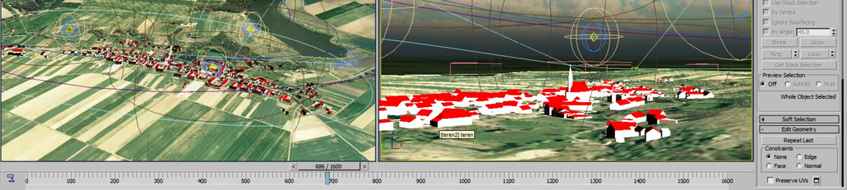
TLS point cloud as a data surce for multi-lod of 3D models
Corresponding author
DOI: http://dx.doi.org/10.15576/GLL/2022.2.63
The development of science and technology had a strong impact on all branches of engineering, including geodesy and the possibility of acquiring and processing measurement data. The best example of this is the Terrestrial Laser Scanning, whih can perform measurements in the form of a multi-million-point cloud. The cloud, representing places and objects, becomes a spatial database. The current problem in engineering is no longer data acquisition and processing, but information excess and redundancy. The solution to this problem is optimisation, which is the process of reducing the amount of data. It should implement its assumptions in such a way as to
remove or reduce unnecessary information without losing the information presented by an object. This issue is particularly important in the process of using point clouds in 3D modelling at various levels of detail. The appropriate levels of the LOD0–LOD4 model require a different type of data: on the one hand ensuring the obtainment of the appropriate accuracy class in the study, and on the other hand, the data source should not contain too detailed information that is unnecessary for the study, which makes the work harder and slows it down due to the need to operate on a huge amount of redundant information Therefore, the purpose of this paper is to determine the scope of work on the optimisation of the point cloud in order to adjust its number and quality to the needs of individual LODs. The results of the work allowed to determine the
scope of data unification for the respective precision groups of 3D models generating.
Keywords: data optimisation • point cloud • TLS • LOD • 3D modelling
The third issue, No. 3 (2022)
Magdalena Jurkiewicz ![]()
Legal and technical aspects of the inclusion of the gesut database in the 3D cadastral system
Corresponding author
DOI: http://dx.doi.org/10.15576/GLL/2022.3.9
The inclusion of information on utility networks and facilities into three-dimensional cadastres has been discussed for years. The concept of cadastre has changed its meaning from a traditional form of a legal and fiscal register to a three-dimensional multitasking system that combines data on real estate obtained from various spatial databases. This shift follows the development of construction technology and increasingly complex design of buildings and structures as well as related networks and technical equipment. Due to the increasing densification of infrastructure networks, a 2D plane representation cannot guarantee that their full management potential is reached. The lack of complete, reliable information on the location of cables, especially those underground, is causing many accidents and network damage, which have serious financial costs. Therefore, it seems appropriate to include information on the layout of the utilities infrastructure in the 3D cadastre, which would complement the relevant property data.
The paper aims to analyse Polish legislation regarding the possibility of including network objects and utilities in the 3D cadastre. In the Polish context, these objects are registered in the utilities network database (GESUT). Thus, the analysis covered the legal acts relating to the functioning of that database. In addition, the technical possibilities of converting data from the existing two-dimensional GESUT database to its 3D form were analysed on the ground of existing research studies.
Keywords: 3D cadastre • utilities networks • GESUT
Jacek Kuśmierski ![]()
Management of herbaceous vegetation in historic gardens – the north landscape garden of Wilanów palace
Corresponding author
DOI: http://dx.doi.org/10.15576/GLL/2022.3.17
Herbaceous vegetation is a critical component of the multi-layered arrangement in historic gardens, enhancing its harmony and natural balance. Despite its numerous advantages, such as limiting weed growth, inhibiting soil degradation, and increasing biodiversity, it remains one of the most neglected components of historic gardens. The objective of this article was to present practical guidelines for the management of herbaceous vegetation in the North Landscape Garden of Wilanów Palace made for the Museum of King Jan III’s Palace at Wilanów between 2017 and 2018. Analytical studies and design works were conducted for an area of 5.3 ha. Following the principles of conservation with respect to spatial forms and landscape features with simultaneous reference to the composition of natural plant communities and preservation of the existing natural qualities, a list of 106 dominant and coexisting plant species was proposed. Herbaceous vegetation covered in total 39% of the park’s area. The identified species indicated a habitat of subcontinental oak-hornbeam forest (Tilio-Carpinetum calamagrostietosum) and willow-poplar marsh (Salici-Populetum). In addition, compositional guidelines and recommendations for implementation, care and use were specified. The correct management of herbaceous vegetation in a historic garden requires a well-thought-out design and implementation process that accounts for cultural values and habitat conditions.
Keywords: Wilanów • historic garden • landscape garden • herb layer • herbaceous vegetation
Justyna Wójcik-Leń ![]() , Przemysław Leń
, Przemysław Leń ![]() , Arkadiusz Doroż
, Arkadiusz Doroż ![]() , Barbara Kępowicz
, Barbara Kępowicz ![]()
Hierarchisation of needs with regard to land consolidation works in the villages of southern poland on the example of the Haczów municipality
Corresponding author
DOI: http://dx.doi.org/10.15576/GLL/2022.3.31
The aim of the research was to determine the needs with regard to land consolidation works and land exchange in the villages of the Haczów municipality. The analysis of the spatial structure was based on the calculated factors, and the following paper follows the applied statistical method to determine the necessary sequence of works in the studied area. It includes seven cadastral districts of the Haczów municipality, i.e. Jabłonica Polska, Wzdów, Jasionów, Buków, Haczów, Malinówka and Trześniów, located in the Brzozów district, in the Podkarpackie Voivodeship. The study had to take into account the structure of land ownership, land use, fragmentation of cadastral plots, and plots with no direct access to a public road. It also includes the calculation of the productivity index of arable land and grassland, as well as specific sizes of the occurrence of the external chessboard of land, i.e. differentials of local and nonlocal land. The analyses allowed us to determine, first, the factors characterising individual localities, and then to present the hierarchy of consolidation works and land exchange in the form of a ranking. The study applies the common method of zero unitarisation. This method consists in normalising diagnostic variables using feature range control. The obtained measures are included in the range [0.1]. The results represent the average optimal value of the measures obtained by each of the individual objects. The position in the ranking of urgency of the land consolidation works and land exchange depends on the size of the synthetic measure obtained. The analysis was based on data obtained from the Land and Building Register of the District Office in Brzozów.
Keywords: land consolidation • land exchange • spatial structure of land • land chessboard • agriculture
, Imen DibEffect of the agriculture on the quality of groundwater in the alluvial aquifer of the Tadjenanet area (eastern Algeria)
Corresponding author
DOI: http://dx.doi.org/10.15576/GLL/2022.3.45
The region of Tadjenanet is in eastern Algeria in the high plains, characterized by a varied age detritus Mio-Plio-Quaternary. Some geological formations can be an important source of groundwater (alluvial sand, shell limestone, gravel). Its location in semi-arid area involves evaporation pronounced even tilt the balance in a chronic deficit, excluding periods characterized by rainfall events.
Agriculture in the study area is the first socio-economic activity and the largest consumer of water resources. It is therefore necessary to consider for effective water management. Indeed, the combination of hydrogeological and hydro chemical geological mapping, geophysics, harvested from field data and their interpretations can be an excellent tool for deciding the suitability of water for irrigation.
The analysis of the physicochemical data shows an increase in the concentration of nitrates reaching 200 mg · l–1, as well as the analysis by the Richards SAR parameter shows that most groundwater samples are generally suitable for agricultural purposes with 33%, belong characterizing poor quality.
Indeed, the groundwater in the region generally requires prior treatment before consumption and use depending on the type of crop.
The assessment of the quality of the water in the region and its consequences on the soil and the types of crops has enabled the authorities concerned to manage the water supply adequately to preserve and protect this vital source for the future from any risk of contamination.
Keywords: effect • groundwater • salinity • quality • irrigation • Tadjenanet • Algeria
Dawid Kudas ![]() , Agnieszka Wnęk
, Agnieszka Wnęk
Accuracy of determining height differences based on NRTK VRS measurements and using quasi-geoid model
Corresponding author
DOI: http://dx.doi.org/10.15576/GLL/2022.3.59
The paper analyses the accuracy of the determination of normal heights in the national spatial reference system using the PL-geoid-2011 quasi-geoid model. The heights were determined using the PL-EVRF2007-NH normal height system. The paper discusses the results of a measurement experiment consisting in measuring 8 points with the use of the Network Real Time Kinematic (NRTK) technique and the Virtual Reference Station (VRS) surface correction generated on the basis of the TPI NETpro commercial network of reference stations and with the use of two global satellite systems (GPS, GLONASS). In the experiment, three measurement schemes were evaluated in relation to the number of measurement epochs recorded above the designated point, as well as the order of recording points. The conducted measurement experiment allowed to determine which of the proposed schemes guarantees the best accuracy from the point of view of establishing a height measurement network with the use of the NRTK technique and VRS corrections. The tests showed that it is possible to determine the height difference between points using the NRTK technique and the VRS method with an accuracy of 0.01m. However, to ensure adequate accuracy, elevation differences must be defined as the differences of the measured heights and should be determined several times and based on independent measurements at the beginning and end of the levelling section. Thus, determining elevation differences with the use of the NRTK VRS technique may be particularly effective in areas with large differences in height, where the determination of elevation differences with the use of classical methods is time-consuming. The obtained elevation differences require tying to the points of the height control network with the use of classical methods
Keywords: VRS • NRTK • PL-geoid-2011 • height • quasi-geoid
Planning measurement campaigns for precise GNSS positioning in various observation conditions
Corresponding author
DOI: http://dx.doi.org/10.15576/GLL/2022.3.75
Currently, GNSS (Global Navigation Satellite System) positioning systems are becoming widely used not only in geodesy, but in broad positioning in very many areas of the economy and society. The growing popularity of GNSS, especially recent, is related to their significantly increasing availability and a reduction of measurement time to a minimum, while maintaining high positioning accuracy. High positioning accuracy is ensured, among other things, by applications that allow planning observation sessions so that measurement is taken at the best time windows. It is the moment when the impact of measurement errors due to the constellation of observed satellites is the smallest. The following paper presents an example of the use of such an application and its benefits for planning GNSS observations. This type of research is particularly important for urban areas, where conditions for receiving GNSS signals are particularly difficult. Increasing the number of observable satellites and simultaneously minimizing the value of the Position Dilution of Precision (PDOP) parameter allows obtaining position coordinates (3D) with high accuracy from the point of view of relevance to GNSS measurements. The paper demonstrates the fundamental significance of satellite constellation geometry for GNSS applications requiring high accuracy position determinations, for which correct planning of a measurement campaign is crucial. It avoids this way large errors or conditions that render the observations of a particular GNSS measurement method impossible.
Keywords: GNSS • DOP • satellite observation planning • Mission Planning
Network analyses with the use of spatial databases
Corresponding author
DOI: http://dx.doi.org/10.15576/GLL/2022.3.93
An analysis is the process of browsing and searching for specific information from an entire dataset. The simplest analysis that can be performed on the data is visual analysis. However, it does not provide absolute certainty as to correctness and quality. A more advanced way of selecting required data is computer-based analysis. Analytical operations are performed on the data entered into the computer. The user defines the query, and the program performs calculations and displays the answer on the monitor screen. The aim of this publication is to conduct network analyses with the use of spatial databases. Besides focusing on the analysis as the leading research method, the paper also adopts this method to analyze the literature on the subject. In addition, the paper points to the complementary roles of the raster model and the vector model, emphasizing their coexistence.
The paper shows a variety of applications of GIS analyses, from simple buffers around selected areas, through selection, and the intersection of layers, to network analyses. The high degree of advancement of GIS tools allows to build advanced models in which analyses that go beyond the original application of the collected databases can be run.
Keywords: geographic information system • databases • network analysis • space management • raster data model • vector data model
Karstic landscape detection using electrical resistivity tomography in northeast Algerian
Corresponding author
DOI: http://dx.doi.org/10.15576/GLL/2022.3.103
Sinkhole (doline) collapse is one of the major natural hazards threatening people and property in the Middle East and North Africa (MENA) region, especially if the bedrock structure is epi-karstic, covered by encrusted material. Many dolines-avens collapses have been recorded in urban and rural areas in Northeast Algeria. Our study identifies localized deformation that may be caused by a sinkhole activity based on the electrical resistivity tomography (ERT) imaging in Setifian high plains. For this task, we conducted 2-D Wenner and Wenner-Schlumberger transects profiles. The geological and hydrogeological study helped to calibrate the resistivity model, and in this regard, expound on the proneness of the limestone layer to collapse. The obtained model highlights the heterogeneity of the subsurface. The inverted transects allowed the investigation of 20 m depth with Wenner array and 52 m with Wenner-Schlumberger. The Wenner inverted models imaged the chimney and different karst networks until 20 m depth; even as the Wenner-Schlumberger models imaged a new karstic cavity in the limestone layer. ERT imaging has once again proven its effectiveness in mapping sinkholes based on its ability to detect resistivity. Our research can certainly benefit karst collapse monitoring in other areas of the high plain region.
Keywords: natural hazards • doline • geophysical survey • resistivity • underground voids
Surveying and cartographic aspects of utility networks in Slovakia and Poland
Corresponding author
DOI: http://dx.doi.org/10.15576/GLL/2022.3.117
Utility networks provide transport for various types of raw materials. They comprise a network of pipes, cables and ducts running on, under and above the surface of either ground or water. They connect individual customers with distributors within water supply, sewage, heating, telecommunications, electricity, as well as oil, gas and chemical networks. They serve an extremely important role in today’s urbanised world. However, utility networks require specialised treatment not only in legal, technical or social terms, but also geodetic and cartographic.
It is necessary to conduct a precise and accurate inventory to prepare and implement projects of utility networks, as well as all kinds of other construction works. Mapping is another task required, along with the preparation of databases on networks that provide comprehensive (graphic and descriptive) information on objects. In each country, the execution of surveying and cartographic works observes internal laws and technical standards and norms. This paper presents the issues of surveying and cartographic works in relation to utility networks, as well as their implementation in Slovakia (Bratislava) and Poland (Kraków). The rules for the presentation of networks on maps, as well as technical standards for collecting, processing and sharing network databases based on legal provisions that are valid for both countries, were compared.
Keywords: utility networks • cartography • cartographic objects • legal and technical standards
Geomatics-based assessment of the neotectonic landscape evolution along the tebessa-morsott-youkous collapsed basin, Algeria
Corresponding author
DOI: http://dx.doi.org/10.15576/GLL/2022.3.131
The neo-tectonic research is interested in the study of the movements of Earth’s crust in recent geological times. It could explain the deformation mechanisms that lead to the structuring of drainage catchments. The Morsott-Tebessa-Youkous (Chabro) collapsed basin corresponds to a subsiding depression framed by brittle structures and filled with thick deposits. Our work aims to unveil the neo-tectonic activity and reconstruct the morphometric evolution of the landscape and the drainage network of the basin. For this task, our investigation applies a quantitative analysis of geomorphic indices extracted from the DEM of the study area. We used a GIS-based approach to compile seven morphometric factors namely Integral Hypsometry (HI), the Sinuosity of mountain fronts (Smf), the Valley Floor width to height ratio (VF), the Asymmetry Factor (AF), Basin Shape index (BS), and the topography (T). All these thematic parameters were processed in a Geo-database to calculate the study area’s Relative Tectonic Activity Index (IRAT) as a result. The IRAT map was categorized into three classes. The result highlighted the distribution of relative tectonic activity in the region and unveiled some unknown faults. It associated the sinuosity of rivers and the deformation of the substratum with active tectonic anomalies. This research work succeeded in drawing up a new scheme of the neo-tectonic activity and morpho-structural evolution in the collapsed basin.
Keywords: tectonic activity • hypsometry index • sinuosity • asymmetry • topography
The fourth issue, No. 4 (2022)
Abdelmouhcene Chibani , Riheb Hadji ![]() , Hamed Younes
, Hamed Younes
A combined field and automatic approach for lithological discrimination in semi-arid regions, the case of geological maps of bir later region and its vicinity, Nementcha mounts, Algeria
Corresponding author
DOI: http://dx.doi.org/10.15576/GLL/2022.4.7
The Sahara’s Nememcha mountains chain suffers from a significant lack of large-scale geological information. In the Bir Later region with complex morpho-structural settings and arid climate conditions; geological maps have not been yet completed by competent authorities. However, this region harbours Algeria’s largest phosphate mine; with its reserves estimated at more than one billion tons of ore grading 20% phosphorus pentoxide. Geomatic-based techniques of Multi-source Remote Sensing data allow the classification and identification of the lithologic features. The adopted method quarries the spectral signal, the alteration processes, and the thickness of the rocky banks. For this task, we apply Principal Component Analysis (PCA), Minimum Noise Fraction (MNF), directional filters, and unsupervised classification (K-Means data) techniques to calibrate and correct Landsat 8 OLI and Sentinel-2A multispectral images. A petrographic study with field and laboratory work was carried out in order to confirm the machine description of the different facies. The results showed that the proposed lithology classification scheme can achieve accurate classification of all lithologic types, in the Cenozoic, Mesozoic, and Holocene deposits of the study area. The lithological map obtained from the GIS-RS-Processing is highly correlated with our field survey. Therefore, multispectral image data (Landsat 8 OLI and Sentinel-2A) coupled with an advanced image enhancement technique and field surveys are recommended as a rapid and cost-effective tool for lithologic discrimination and mapping. The experimental results fully demonstrated the advantages of the reliance on laboratory tests in the sensed lithology validation in an arid area.
Keywords: Nememcha mountains • PCA • MNF • directional filters • unsupervised classification
Ali Ahmed Benyoucef , Larbi Gadri, Riheb Hadji ![]() , Faouzi Mebrouk, Elhaddi Harkati
, Faouzi Mebrouk, Elhaddi Harkati
Mining operations and geotechnical issues in deep hard rock mining – case of Boukhadra iron mine
Corresponding author
DOI: http://dx.doi.org/10.15576/GLL/2022.4.27
Underground mining operations are a very problematic task, especially in poor geotechnical conditions. The right choice of excavation and support techniques leads to adequate and secure mining operations. This should ensure the overall stability of the underground mine with the best productivity and stability performance. In this paper, an empirical model for obtaining support systems for underground galleries was applied. Then, a numerical model for the evaluation of the performance of support measures for rock masses in the Boukhadra iron mine was introduced. Extensive field and laboratory tests were performed to obtain geological, geotechnical, and mechanical data on the entire geologic formations of the (1105 m) level. The performance of the design is supported by the selection of a common support plan between RMR, Q, and UBC systems for each geotechnical unit. Therefore, the rock masses classification based on the geo-mechanical model has determined the suitable support systems. The finite element model (FEM) was used for the analysis of rock mass behaviour, displacements, stress, and plastic point distribution. The results permit the optimization of the plastic zone thickness around the gallery. The outcomes of this study could improve the stability of the mine by choosing the right direction of excavation in consideration to the direction of the discontinuity planes. In order to choose between the current and the recommended mining operations, an equivalent calculation sequence was verified. Our study demonstrated that the consideration of discontinuity sets in the orientation of excavation highly improves the mining conditions with or without support.
Keywords: geo-mechanic • mining gallery • discontinuity • iron ore • underground mines
Nabil Manchar , Riheb Hadji ![]() , Ahmed Bougherara, Kamel Boufaa
, Ahmed Bougherara, Kamel Boufaa
Assessment of relative-active tectonics in rhumel-smendou basin (ne Algeria) – observations from the morphometric indices and hydrographic features obtained by the digital elevation model
Corresponding author
DOI: http://dx.doi.org/10.15576/GLL/2022.4.47
The eastern Tell Atlas of Algeria is characterized by a complex neotectonic system including lateral strike-slips, and normal and reverse faults. The landscape of the Neogene basin of Mila-Constantine acquired its shape due to the perpetual action of tectonic activity, and erosion processes. Neo-tectonics in this basin have affected the geometry of the stream network and the contemporary landscape topography. Our methodology evaluates the active tectonics in this mountainous region by a combination of drainage network and geomorphic indices, namely, the basin-shape index (Bs), stream-length gradient (SL), hypsometric integral (HI), mountain front sinuosity (Smf), basin asymmetry factor (AF), and valley-floor ratio (Vf). The calculated values of the six measured geomorphic indices were used to differentiate the distribution of faults function as well as the relative tectonic activity in the study area. The obtained results from the GIS-based multi-criteria analysis of these indices consist of the index of active tectonics (IAT). Hence, we defined four hierarchic degrees of IAT, namely, very high (VH), high (H), moderate (M), and low (L). The relative active tectonics represents an obvious correlation between morpho-structural features, tectonic activities, and uplift rates. It selects the morphotectonic features and landforms that interpret the tectonic events in the study area. Our results prove that this approach discerns the most active regions related to the neo-tectonic action in the Rhumel-Smendou drainage basin. The combination of geomatics and field surveys highlights the cliffs which are still rising by using the drainage patterns, the landform model, and the mountain range shape.
Keywords: Bs • SL • Hi • Smf • AF • Vf • IAT
, Karim Zighmi, Abdelmouhcene ChibaniApplication of geomatic tools for the diachronic monitoring of landscape metrics in the northeastern algerian highlands, case of the city of Setif
Corresponding author
DOI: http://dx.doi.org/10.15576/GLL/2022.4.67
Geomatic tools could be used efficiently for urban development planning. The problem of the study lies in the extensive land use of terrains that are now suitable for heavy construction which slows down the development of new facilities. Furthermore, the authorities are forced to plan future settlements around Setif, at a distance of 8 to 12 kilometers from the city limits, threatening the long-term viability of construction and the ring of farmland that connects them to the core city. This must be done during the planning stage based on a diachronic analysis of all the natural and physical factors/parameters. The main objective of this research is to explore the application of landscape metrics to the analysis and monitoring of urban growth in the city of Setif, north-east of Algeria. For this purpose, our research paper uses Geographic Information System (GIS) and Remote Sensing (RS) techniques based on Principal Component Analysis (PCA) and the Angle Mapper Algorithm (SAM) target method for the analysis of urban land planning and sustainable urban planning of Setif. In the result of these analyses we propose suitability/buildability maps with more suitable construction sites. The research method is based on a 17-year time series dataset compiled from the Sentinel 2A and Landsat imagery between 2004 and 2021. Additionally, we used a cadastral Vs geotechnical overlay to estimate soil capacity. This work proves again that the integration of RS and GIS techniques allows for scientific identification of the lands suitable for urban development (LAUP).
Keywords: LAUP • GIS • RS • PCA • Sentinel 2A • Landsat
Bogdan Jankowicz ![]()
The concept of smart city development in the context of the Covid-19 pandemic on the example of Kraków and Barcelona – cities combining tradition with modernity
Corresponding author
DOI: http://dx.doi.org/10.15576/GLL/2022.4.81
The concept of a smart city is still being developed despite the lack of a single universally accepted definition. It is implemented through different approaches in different cities around the world. The presented study concerns the improvement of this idea and the possibility of applying the solutions from Barcelona to the city of Kraków. This paper is based on the author’s experience and observations during a trip to Catalonia and its capital – Barcelona – as well as a study of literature on the smart city. The author takes into account the specific topographical and environmental conditions of each city and the human-environment interactions that have shaped both cities over the centuries. The paper continues to focus on the challenges to smart cities following the COVID-19 pandemic. The pandemic has demonstrated the need to modify ICT (Information and Telecommunications Technologies) applications related to the functioning of the city. Preliminary conclusions drawn from the pandemic also indicate that further development of smart cities should be based not only on ICT applications in public services and public spaces, but also on guaranteeing individual spaces for citizens to live in long-term isolation. In addition, attention was drawn to the need to improve both direct and electronic communication, especially by telephone with the authorities of Kraków, to enable “co-governance” in areas where the voice of the city’s residents can be very valuable.
Keywords: ICT • urban development • urban environment • smart city • COVID-19 pandemic
Land clayey deposits compressibility investigation using principal component analysis and multiple regression tools
Corresponding author
DOI: http://dx.doi.org/10.15576/GLL/2022.4.95
The settlement and compressibility magnitude of the major clayey and marly sediments in Tebessa area (N-E of Algeria) depends on several geotechnical parameters such as compression Cc and recompression Cs indices. The aim of this study was to investigate the parameters related to soil compressibility through tools of statistical analysis, which save time in comparison to multiply repeated laboratory tests. The study also adopted the principal component analysis (PCA) method to eliminate a number of uncorrelated variables that have no influence on the compressibility magnitude, or their impact is insignificant. The highest mean correlation coefficients were obtained for different contributing parameters. Multiple regression analysis has been performed to obtain the best fit model of the output Cc parameter taking into account the best correlation by adding parameters as regressors to reach the highest coefficient of regression R2. The final obtained model of the present case study gives the best fit model with R2 of 0.92 which is a better value compared to different published models in the literature (R2 of 0.7 as maximum). The chosen input parameters using PCA combined with multiple regression analysis allow identifying the most important input parameters that noticeably affect the soil compression index, and provide with the best model for estimating the Cc index.
Keywords: compressibility index • geotechnical parameters • principal component analysis PCA • multiple regression models
Evaluation of the capabilities of satellite images alsat 2-a for emergency mapping in urban areas, case of the city of m’sila (Algeria)
Corresponding author
DOI: http://dx.doi.org/10.15576/GLL/2022.4.109
In this paper, we will show the capabilities and limitations of Alsat-2 images in mapping urban areas in emergency situation. The aim of the research was to provide urban information that is geo-referenced in real time during natural disasters (floods, earthquakes). It’s important for fast decision-making so that they will be a necessary support for the estimation of the damages.The following study tests the spatial and radiometric quality of Alsat 2-A images and proposes technical solutions for theiruse in urban mapping.
In order to identify and extract the ground realities, we shall describe and make an effort to discern the perceptible aspects of features in urban area. The adopted methodology carries out a statistical analysis of the information extracted from Alsat-2 images of the studied area (the city of M’Sila, Algeria) using classification and segmentation methods. The statistics will show the percentage of the area in relation to the total size of geometric surface and the distance for linear objects. As a result, the quality of the extracted urban texture necessary for urban mapping will be determined. Image processing to improve resolution quality was carried out using merging method. However, the analysis of consistency and discrepancy of these statistics will be done by comparing samples of field data using confusion matrix.
Keywords: urban mapping • Alsat-2A • image processing • disaster management
Transformation of geodetic heights between local reference systems – algorithm for rigorous adjustment
Corresponding author
DOI: http://dx.doi.org/10.15576/GLL/2022.4.123
The topic of transformations between planar or spatial coordinate systems has been extensively addressed in the literature for years. Usually, researchers present in scientific papers the definitions of iterative algorithms or analytic solutions of 2D or 3D transformations. However, there is a gap in the field with regard to 1D (vertical) transformations. It seems to be quite easy to fill, as it is sufficient to determine one parameter – the vertical shift, i.e. the height difference between two local reference levels. For this purpose, a single (at least) adjustment point is needed, i.e. a surveying benchmark of known heights in both reference systems. However, there is no precisely defined model of rigorous adjustment for a larger number of adjustment points (s > 1). In this paper, the Authors’ have shown several variants of transformations between vertical coordinate systems. These variants include different approaches to weighting the “observations” (heights of adjustment points), such as transformation without weighting and transformation with weighting dependent on the distance between adjustment points (horizontal and vertical distances). Each of the variants was developed in two successive approaches: without transformation corrections and with post-transformation corrections. The research arrived at the latter analogically to the corrections used in planar coordinate transformations (a modification of post-transformation Hausbrandt correction). The analyses made it possible to draw general conclusions determining the relationships between weighting the observations together with applying post-transformation corrections, and the results of height transformation. These findings can become the basis for developers of geodetic computing systems, in terms of the possibility of extending them with a 1D transformation module (in addition to 2D and 3D transformations).
Keywords: 1D transformation • post-transformation corrections • transformation weighting
Landslide stability analysis with the use of the design of experiments method – case study of souk ahras, Algeria
Corresponding author
DOI: http://dx.doi.org/10.15576/GLL/2022.4.137
In the northeast of Algeria, Souk Ahras area is known for the severity and spread of landslides, especially in Mechroha and Zaarouria municipalities. Stability analysis of landslides in these areas depends on the calculations of safety factor according to several parameters (physical, mechanical, geological…). The aim of this study is to investigate the parameters affecting the safety factor using the design of experiments (DOE) method, central composite design (CCD) and response surfaces methodology (RSM). These methods use parameter modeling and optimization to discuss a solution of landslide hazard by developing models of safety factor (Fs) considered as response. The other parameters adopted as input independent factors are geotechnical physical and mechanical parameters such as: the dry and wet unit weight (γd, γh), the water content (w), the plasticity and liquidity limits and the plasticity index (WL, WP, IP), the percentage of fine elements Ff (%) < 0.08 mm), the cohesion C and the internal friction angle (Phi). Obtained results show high correlations with a regression coefficient R2 of 0.88 and 0.93 in the two cases study and the predicted factor of safety model fit best to those obtained in the analytical and numerical modeling procedure. The final model is applicable to give reliable results on the safety factor of landslides.
Keywords: landslides • Souk-Ahras region • numerical modeling • safety factor • geotechnical parameters • design of experiments DoE • response surface methodology RSM
Owner of the Journal
University of Agriculture in Krakow
Faculty of Environmental Engineering and Land Surveying
Balicka st., no. 253a, 30-198 Krakow, Poland
phone: +48 12 662 45 32, fax +48 12 662 45 03
e-mail: gll@urk.edu.pl
Publisher
Publishing House of the University of Agriculture in Krakow
29 Listopada av., no 46, 31-425 Kraków, Poland
phone: +48 12 662 51 51, fax +48 12 662 51 59
e-mail: wydawnictwo@urk.edu.pl
e-mail: iwona.pisiewicz@urk.edu.pl