(ISSN 2300-1496)
(ISSN 2300-1496)
(ISSN 2300-1496)
(ISSN 2300-1496)
(ISSN 2300-1496)
(ISSN 2300-1496)
(ISSN 2300-1496)
The first issue, No. 1
The second issue, No. 2
The first issue, No. 1 (2023)
Fatih Boucenna  , Bilal Fenazi, Mechati Boukoffa
Groundwater investigation in saharan areas using statistical and stable isotope approaches – el golea central south of Algeria case study
Corresponding author
DOI: http://dx.doi.org/10.15576/GLL/2023.1.7
Groundwater quality determination and age estimation in a desert landscape of El Golea province situated in the south of Algeria has been investigated in the present research paper. For this regard, 57 water samples were collected from an aquifer composed of two superimposed systems; phreatic and deep continental intercalary (CI) aquifers which are a part of the Northern Sahara Aquifer System (NWSAS). Samples were analyzed to assess the age and water quality using descriptive, multivariate statistics (PCA and HCA) and stable isotopes. It is revealed that more than 71% of the IC points are characterized by a water type (Ca2+, Mg2+) (HCO3–)2 and more than 83% of the TC samples are defined by a water type (Ca2+, Na+) (HCO3–, SO42–) and very high salt ions contents due to the influence of surface water, evaporate leaching and irrigation water return. The isotopic composition of samples of phreatic and CI aquifers shows a clear difference between the two qualities of water. The phreatic aquifer is characterized by the δ18O range from –4.68 to –6.1, whereas δ2H from –47.25 to –59.48 and CI with values of the δ18O range from –5.96 to –7.6, and δ2H range between –53.7 and –65.78 isotopic signature. The unconfined aquifer above IC forms a special case of a mixture of ancient water from deep horizons and recent water strongly enriched from shallow horizon lands.
Keywords: Albian aquifer • geochemistry • statistical approaches • stable isotopes • Saharan land
Przemysław Klapa ![]()
Integration of terrestrial laser scanning and uav-based photogrammetry for heritage building information modeling
Corresponding author
DOI: http://dx.doi.org/10.15576/GLL/2023.1.23
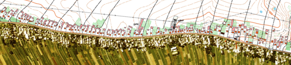
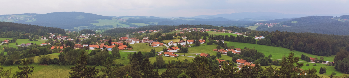
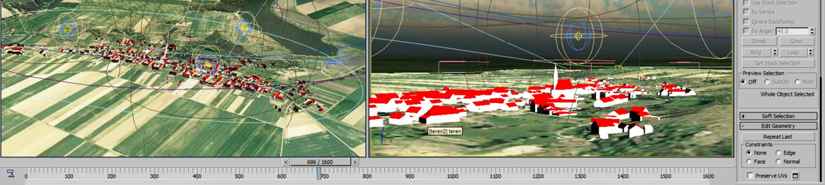
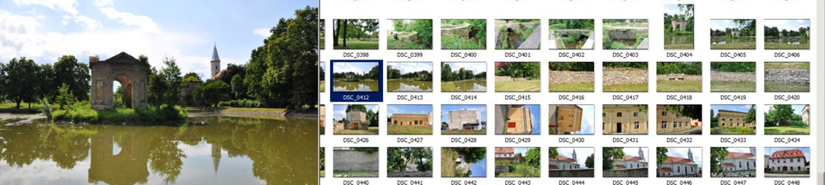
Building Information Modeling (BIM) is the process of generating 3D models based on object databases. They are made for various types of buildings, sites and objects, and their task is to represent all the structural and architectural features of the object using parametric models. The BIM technology involves the preparation of the model that is already at the design stage of the building, in such a way that it is used during conceptual and implementation works, as well as during its final operation. However, a BIM model of existing objects can also be generated. Historic buildings are a special group of objects The HBIM (Heritage Building Information Modeling) model is used not only as an inventory of the object in its current state, but also as a background and a tool for visualising the object in its restored state, or as a source of information about the building itself for conservation, renovation and documentation purposes. Such a model can be created based on various types of source data. The basis for the development of the BIM model can be formed by data acquired during the inventory of the facility using surveying methods, laser scanning and photogrammetry. This paper presents the process of data acquisition of a historic object using the example of Lamus Dworski with the use of TLS and UAV. The study also includes the process of HBIM modeling of the object using point clouds as well as photographic documentation and data recorded in the monument card.
Keywords: BIM • data integration • geospatial data • TLS • UAV • 3D model
Monika Piwko , Przemysław Leń ![]()
Assessment of the impact of the Tomaszów Lubelski bypass on the spatial structure of rural areas
Corresponding author
DOI: http://dx.doi.org/10.15576/GLL/2023.1.35
In recent years, the road network in Poland has undergone significant development, meeting the objective of creating a coherent network of roads to ensure the efficient functioning of passenger and freight transport. Linear investments, such as the construction of motorways, expressways or bypasses, are an important element that improves the safety and comfort of the life of residents, and has a significant impact on the economic and regional progress. In addition to the undoubted benefits of constructing a bypass, its possible negative impact on the surrounding agricultural and forest areas should be emphasised. Poor planning and construction of the bypass itself, without prior programming of survey and management works, can lead to disturbances in the spatial structure of neighbouring villages.
This study attempts to analyse and evaluate the impact of the construction of the Tomaszów Lubelski bypass on the spatial structure of rural areas located in the eastern part of Tomaszów County (Lubelskie Voivodeship), which is a 9.58 km long section of the S17 Warsaw – Hrebenne expressway. The study undertook a detailed analysis of only those factors that adversely affect the spatial structure of rural areas. On the basis of research on the subject, factors affecting and significantly changing the spatial structure of rural areas were identified, which allowed to formulate final conclusions regarding the problem of realising linear investments in relation to shaping the space of rural areas.
Keywords: spatial structure • land use • linear investments • bypass • land consolidation • landscape planning
Simplified diffusion analysis – cartography as a tool for combating pandemics
Corresponding author
DOI: http://dx.doi.org/10.15576/GLL/2023.1.45
The transmission of the SARS-CoV-2 virus is a complex and intricate process, but it is possible to efficiently track and contain the spread of the pandemic in a given area by observing the regularities of the pathogen’s diffusion. One of the basic measures to hamper the development of the disease was to reduce the intensity of social contact by banning free movement. An adequate response in selected regions, where the virus develops much more rapidly, is crucial and prevents serious economic damage to many industries. The modern perception of cartography as an interdisciplinary tool can contribute to limiting the diffusion of infection through spatial analyses.
The aim of this paper is to present cartography as a tool to support the “management” of a pandemic. In terms of methodology, the well-known choropleth map method was employed along with spatial structure analyses. The basic category considered within the framework of statistics and econometrics is spatial relationships formulated for the purpose of achieving the set objective in the form of spatial weight matrices. In the analyses presented here, a modified Moran model was used, within which the Authors applied a row-standardised weight matrix using migration data of individual counties. The paper reviews what has been achieved so far, based mainly on European solutions. Insufficient availability of reliable data needed for advanced models (especially in the initial phase of virus spread) means that using migration data from the nearest neighbourhood can be a viable solution. This approach comes down to an analysis of migration and the population density in the county in question. A simplified analysis with a statistically significant probability allows the identification of counties that could potentially become sites of uncontrolled virus transmission in areas of high population density and high mobility. This is undoubtedly the main achievement of the publication.
The results obtained converge approximately with the actual development of a pandemic. The studies carried out indicate that the development of a pandemic is influenced not only by the number of infections, but above all by population density, as well as economic, social, educational and transport networks, as shown by the high Pearson coefficient correlation of 0.83. The analyses indicate the possibility of uncontrolled transmission of the virus in areas of high population density and high mobility.
Keywords: cartography • spatial weight matrix • SARS-CoV-2 • COVID-19 • choropleth map • pandemic combating model
Renata Ostrowska ![]()
Impact of eu funds on the development of mountain areas in the period 2007–2013 – the example of the Lipnica Wielka municipality
Corresponding author
DOI: http://dx.doi.org/10.15576/GLL/2023.1.57
European Union support is often very important at the beginning of an investment, especially when own resources are insufficient. EU funds provide Poland with a range of development opportunities, and whether they are used appropriately depends mainly on their proper management. Lipnica Wielka is an example of the use of such funds, especially in the period 2007–2013, when the funds were primarily intended to improve the quality of life of residents. The investments in infrastructure should have a positive impact on tourism in the area. The municipality’s main assets are its clean air and attractive location. Advanced organic farming together with a well-developed recreational and agrotourism base have been adopted as the main target of the Municipality’s Local Development Plan. The material benefits of the development of tourism and agrotourism are expected to improve the standard of living of the municipality’s residents. The aim of the paper is to analyse the use of grants received from the EU funds and to determine their impact on the development of the municipality. The largest investment included the extension of the sewerage system and the sewage treatment plant. Only 3% of the total funds were allocated to the development of tourism and agrotourism. The objectives of the Municipality’s Local Development Plan were not achieved within the set time frame.
Keywords: European Union • EU funds • mountainous areas • rural renewal
New technologies in real estate market analysis
Corresponding author
DOI: http://dx.doi.org/10.15576/GLL/2023.1.65
The aim of the study was to present new technologies that are useful for obtaining spatial information on real estate and integrating the data with existing databases maintained by public administration agencies. The technologies presented include the use of GIS tools combined with vector data representing cadastral parcels, and raster data acquired by LiDAR technology. The study also employs descriptive data containing transactional information. The application of these new tools for obtaining spatial information provides real estate market operators with additional data that allows for more reliable market analysis. The methodology of this work has been divided into two parts, the first part related to the creation of a real estate database as a reference for the acquisition of spatial data. The second part was dedicated to the acquisition, processing and analysis of spatial conditions in the study area.
The study used the data on transactions to determine the parcels for which data on elevation situation were acquired. LiDAR data was then applied to the determined parcels to generate the DTM. The obtained terrain elevation model was processed by raster tools, which created maps of slope and maps of aspect.
Currently the data on the features of properties found in real estate price registers maintained by public administration agencies are becoming more accessible in result of the ongoing digitisation of administrative offices in Poland. However, these data do not contain information on slope and aspect – two real estate features that are crucial for surveying areas with varied relief. The presented analysis draws attention to new ways of acquiring spatial data and integrating it with existing databases. Finding ways to integrate data obtained from public administration agencies with modern geographic information systems (GIS) would improve the work not only of valuers, but also of many other real estate professionals (e.g. brokers, developers, bank analysts).
Keywords: GIS • real estate market analysis • terrain slope • exposure of cadastral parcels
Draft of the Zamość development plan of 1939
Corresponding author
DOI: http://dx.doi.org/10.15576/GLL/2023.1.75
The paper is written in the form of a scientific essay. The method used was the analysis of historical and contemporary planning materials, starting from the interwar period. Extensive specialist literature has been studied, especially that which raises the issue of the urban, architectural and cultural values of Zamość. It provides an analysis of the “Draft of the Zamość Development Plan of 1939” (“Szkicowy projekt planu zabudowania Zamościa z 1939 r.”) by the architect Jan Zachwatowicz and the urbanist Władysław Wieczorkiewicz. The paper also describes the circumstances leading to the foundation of Zamość. It draws attention to the elements missing from the contemporary urban development plans of the town, which were present in the excellent pre-war planning work. It also underlies the importance of municipal public transport, which should always be the basis for the delimitation of functional zones. It also includes a brief discussion of the 1994 “General Local Plan for the Spatial Development of the City of Zamość” („Miejscowy plan ogólny zagospodarowania przestrzennego miasta Zamościa z 1994 r.”), which, according to the author, is the best planning document produced after the Second World War. The aim of the study was to highlight those elements that coincided with the idea of the 1939 plan sketched by Jan Zachwatowicz and Władysław Wieczorkiewicz. The paper uses the method of footnotes, which refer the reader to the relevant source material and may also provide additional commentary on the presented content. The three illustrations are photographs of maps (charts) of the 1939 plan. They are also included in the 2018 scholarly monograph “Cartographic zamostiana” („Kartograficzne zamostiana”) by Wojciech Przegon and Jakub Żygawski.
Keywords: Zamość • urban planning • spatial development plan • cultural heritage
The second issue, No. 2 (2023)
Title page, content Maou Zakarya ![]() , Ahmed Bougherara
, Ahmed Bougherara ![]() , Yahyaoui Habibi
, Yahyaoui Habibi ![]()
Sustainability of a hydraulic facility and flood risk of its downstream section: the case of the Foum El-Gherza dam (Ziban east, Algeria)
Corresponding author
DOI: http://dx.doi.org/10.15576/GLL/2023.2.7
Due to advanced silting, the Foum El-Gherza dam has lost more than two thirds of its initial capacity (47 hm3) and is no longer able to withstand the floods that threaten its downstream section. Indeed, the damage recorded in recent years has confirmed the vulnerability of the man-made structures located on both banks of the Oued Labiod. Thus, we believe that the hydrological behaviour of the catchment area is no longer influenced by the dam. Therefore, the hydrological study involved a critical analysis (homogeneity tests) of the hydro-climatic data in order to highlight the characteristics of the historical events recorded during the period 1950–2019. The frequency study of the maximum daily rainfall and floods recorded at the dam allowed us to determine the rainfall and flow rates of the return periods (10, 25, 50, 100, 500 and 1000 years). The flooding of the 28 October 2011 were used as a standard for the calibration of the model calculated by the HEC-Ras software. After validation of the model, a prediction of the water levels and flood extent was made for the selected return periods. The results obtained show that a part of the town of Seryana (district located on the edge of the right bank) suffers from flooding proportionally to the return periods of the floods. In addition, some agricultural areas bordering the Oued are also affected by the floodings. The hazard modelling maps can be considered as a basis for a flood risk prevention plan (PPRI) and as a decision support tool.
Keywords: Foum El-Gherza dam • siltation • flooding • downstream section • modeling
Arkadiusz Doroż ![]() , Michał Rymarczyk, Piotr Bożek
, Michał Rymarczyk, Piotr Bożek ![]()
Using maps of the former austrian cadastre on the scale of 1:2880 to analyse the data in the land and building registry
Corresponding author
DOI: http://dx.doi.org/10.15576/GLL/2023.2.23
The aim of the paper was to present the possibility of processing cadastral data in order to obtain material that could serve as a valuable source of information in the analysis of the current state of records. The paper presents a methodology for processing cadastral data, which provides material that can be compared with data from the Land and Buildings Register (EGiB).
The research area was the Niedzieliska cadastral precinct, located in the municipality of Szczurowa, in the Brzesko district, in the Małopolskie Voivodeship. Based on processed cadastral data and data contained in the EGiB database, the paper determines the differences in the area for 15 cadastral parcels. A comparison of the two records showed that cadastral data allow for analysis of the current state. The implemented methodology confirmed the usefulness of archived cadastral documentation in the analysis of the current state contained in the Land and Building Register. The analysis of the obtained results showed that the differences in the area of the cadastral state and the area of the cadastral parcels exceeded 10% in none of the cases, and the average difference did not exceed 0.0075 ha.
The developed output material can be applied to detect discrepancies and differences between the source data and the current data contained in the EGiB. This makes it possible to identify areas where the causes of discrepancies need to be explained and the necessary corrections need to be made to remove the discrepancies.
Keywords: transformation • cadastre • land and buildings register
Nour El Houda Gueraidia ![]() , Saida Gueraidia
, Saida Gueraidia ![]() , Chemseddine Fehdi
, Chemseddine Fehdi
Sar interferometry for landslide investigation and surface deformation monitoring: a case study of Souk Ahras area, north-east of Algeria
Corresponding author
DOI: http://dx.doi.org/10.15576/GLL/2023.2.37
Landslides – natural disasters be caused by various factors - are frequent in the region surrounding Souk Ahras. Comprehensive fieldwork, such as geotechnical drilling investigations and soil excavations, is conducted to monitor ground movements and assess the feasibility of geological locations. Synthetic Aperture Radar (SAR) and other active satellite remote sensors are utilized in Earth Observation-based systems to identify and track ground deformation and landslides in the study area. This research aims to illustrate how open-source processing software, SNAP, provided by the European Space Agency, can be combined with freely available datasets from Copernicus to accomplish this goal. In the North Eastern part of Algeria, which includes Souk Ahras, there is a high risk of landslides Through the use of InSAR technology, the research provided satisfactory results in identifying the morphology of landslides and generating a large-scale interferometric map covering several regions in the East of Algeria, revealing the extent of distortion and spacing caused by the landslide phenomenon.
Keywords: InSAR • SAR • interferometry • landslides • deformation • Zaarouria • Hammam Tassa • Mevhrouha
, Damian Kasza Terrestrial laser scanning in inventory control of wildlife in a municipal park in Wrocław
Corresponding author
DOI: http://dx.doi.org/10.15576/GLL/2023.2.57
The article presents the results of an experiment related to wildlife inventory control with the use of data from terrestrial laser scanning. The measurements were performed with the terrestrial laser scanning system – Riegl VZ-400i. The study area was the Obrońców Westerplatte square in Wrocław. The collected measurement data were pre-processed in a commercial – dedicated RiSCAN Pro environment. Operations related to point cloud georeferencing and its filtering were performed. The tree parameters were measured on the basis of a cloud point obtained in field surveys. This operation was performed with the use of the 3D Forest software. The investigations covered the main parameters of the tree (height and diameter) along with additional parameters, such as the distance between two points of the tree located furthest apart, the surface area of the orthogonal projection of the tree on the reference surface (terrain surface) and the height of the tree crown above the terrain surface. As a result of the performed analyses, an inventory of 70 trees was made within the Obrońców Westerplatte square in Wrocław. Part of the experiment was also to prepare a 3D model of a tree by using some available modeling algorithms. This part was performed in Sequoia software - dedicated to such operations. The software offers three modeling algorithms: Zhu/Bridson, metaballs and union of spheres.
Keywords: tree inventory • laser scanning • 3D modeling
Joanna Rajca ![]() , Barbara Olczak
, Barbara Olczak ![]() , Magdalena Wilkosz-Mamcarczyk
, Magdalena Wilkosz-Mamcarczyk ![]()
Urban adaptation to climate change and resident awareness. A Polish perspective
Corresponding author
DOI: http://dx.doi.org/10.15576/GLL/2023.2.81
The development of urban areas over the last several decades has significantly contributed to climate change. The modern approach to spatial planning and land management responds to the adaptation of cities to changing climate conditions and the need for a liveable environment. The land use of new green spaces and the upgrading of the existing ones should include adaptation to the present and future climate conditions. Cities can adjust to climate change in many different ways. Over the years, the expansion of urban areas has generated a trend towards higher average temperatures than in rural areas, especially in densely populated urban centres with scarce vegetation where temperatures tend to be higher. City growth is detrimental to the natural environment and water circulation. Insufficient vegetation contributes to high air temperature in cities and urban heat islands. In addition, poor water retention and water infrastructure exacerbate urban droughts and floods. Therefore, efforts should be interdisciplinary and multi-faceted to achieve the best results. Adaptation to climate change faces in Poland multiple and diversified barriers. Hence the question: what is happening at the social level? Are residents of cities conscious of the problem, and do they know how to respond to it? What are the barriers concerning climate change? The paper investigates the public awareness of climate change in Poland. The results demonstrate that there is insufficient awareness of climate change in Polish society and a broad remedial measures are needed.
Keywords: Poland • public awareness • adaptation to climate change • modern cities
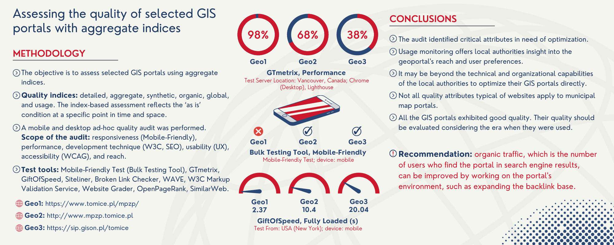
The reach and the trends in the use of the map service for the local spatial development plan of Tomice municipality
Corresponding author
DOI: http://dx.doi.org/10.15576/GLL/2023.2.91
Users are primarily interested in the comfort of use and the range of map service in terms of its functionalities. Publishers, in turn, monitor usage statistics in order to optimize the operation of their websites based on the analysis of these statistics. This also applies to municipal map apps. The present work’s objective is to analyse the reach and trends in the use of the Internet application presenting the local spatial development plan (eMPZP). The monitoring covered the map service of the Tomice municipality – in the Małopolska Region (Województwo Małopolskie), Wadowice district (Powiat Wadowicki), Poland – which is available on the municipality’s server at the Internet address https://www.tomice.pl/mpzp/. The data was collected in the period from January 1, 2013 to May 1, 2023. Selected website usage indicators were analysed. In a period of just over 10 years, the eMPZP application was displayed 31,713 times, of which 25,009 (78.86%) were unique views. The largest number of users was recorded in Poland, i.e. 13,044 (83.52%); followed by the United States, i.e. 565 (3.62%) and the United Kingdom, i.e. 434 (2.78%). Most users found the eMPZP application using search engines and direct links. In conclusion, it was demonstrated that map service usage statistics could be useful for municipal authorities, as they help to understand how the service is used, by whom it is used, and what the users’ preferences are. In addition, it was shown that eMPZP still fulfils a number of selected functions, despite the fact that in 2019 it was replaced by a geoportal (http://mpzp.tomice.pl). Accordingly, it is recommended that the so-called automatic redirection be set, sending the users to the current geoportal using specific HTML tags.
Keywords: information management • decision-making process • user monitoring • usage statistics • map service • Google Analytics
Graphical Abstract

The fourth issue, No. 3 (2023)
Title page, content Use of cartographic data in crisis management
Corresponding author
DOI: http://dx.doi.org/10.15576/GLL/2023.3.7
The subject of the research in this paper was a review and identification of types of cartographic documentation used in crisis management in Poland. The analysis focused mainly on assessing the usefulness of cartographic data for visualising the scale of natural phenomena such as floods, landslides, droughts, wind, and others. The most important map that serves as a reference base for various types of industry-related works, especially derivative geodetic works, is the cadastral map stored in the resources of the Land and Building Register. In this study, the authors concentrate on the possibilities of using cartographic data, with a particular emphasis on cadastral maps, for crisis management purposes. The aim of this paper is to review and provide an expert assessment of the usefulness of cartographic data in emergency situations. The research shows that cartographic data are crucial for each of the mentioned hazards, especially the resources of the Land and Building Register, which allow the visualisation of the spatial and temporal scale of these hazards. The success of the measures taken to reduce the occurrence of floods or landslides, for instance, depends first and foremost on fast and seamless access to reliable and up-to-date information on the terrain. The cadastre is one of the publicly accessible registers providing this data, without which crisis management could not be fully effective. The study was conducted through an online survey using an interactive sheet, dedicated to experts (services dealing with different types of hazards).
Keywords: crisis management • cartographic works • hazard maps • cadastral map
Monika Mika ![]() , Patrycja Fryźlewicz
, Patrycja Fryźlewicz
Cartographic imaging of the development potential of Nowy Targ
Corresponding author
DOI: http://dx.doi.org/10.15576/GLL/2023.3.19
Development potential, studied on the example of the city of Nowy Targ, is defined by the authors as a set of factors contributing to social, economic, and environmental development. Development potential is also understood as a positive change. Properly examined, it provides an opportunity to maintain good practices, such as the protection of ecologically valuable areas or the preservation of traditions directly derived from the region’s characteristics. The methodology used in this study, based on the point bonitation method, has already been applied in the context of ecological and natural assessments of selected territorial units. This publication demonstrates the application of this method to the selection of variables, allowing us to determine the development potential using Nowy Targ as an example. The authors place several indicators in three research sectors: the city’s economy, natural environment, and social development. For the purpose of this study, the city area was divided into 245 squares (PPO) with sides of 500 m × 500 m. The size of the PPOs was chosen with regard to the purpose of the research and adapted to the city’s area. 15 diagnostic variables were adopted in the examination of Nowy Targ’s development potential. The conducted research resulted in a cartographic visualisation of the data using GIS tools. This research provides an opportunity to deepen the analysis of the appropriate choice of development directions when working on municipal development documents. An important advantage of the employed method is its flexibility. A weakness of this method lies in the subjective selection of variables by the researchers and the thematic scope of the chosen research problem. The resulting cartograms allow for a quick assessment of the areas influencing the city’s development or degradation.
Keywords: development potential of cities • choropleth map • point bonitation method
The point location problem on the example of determining map identification number and map sheet extent in the IMW system
Corresponding author
DOI: http://dx.doi.org/10.15576/GLL/2023.3.31
The point location problem is one of the most fundamental topics in computational geometry. This problem is particularly well illustrated in the context of maps. In order to determine a point location, it is necessary to work in a specified space, with known division rules. A practical example can be a map sheet division system adopted for the International Map of the World. Given the current advancements in spatial data acquisition and growing availability of spatial data sets, it has become necessary to design an algorithm to identify a map sheet corresponding to a selected point. Available digital data, e.g. orthophotomaps or LiDAR-based data sets, cover whole countries. Due to the size of such data sets, they need to be divided into smaller chunks. The article presents a method of determining a map sheet identification number and a map sheet extent based on the latitude and longitude of a selected point. An inverse problem has also been addressed, allowing a map sheet extent to be identified based on a map sheet identification number. The algorithms developed might be directly implemented in GIS software. They are presented in a ready-to-implement form in the Basic programming language with the use of basic data structures.
Keywords: IMW • index map • geometrical geodesy
Aggregated indices in quality assessment of selected geoinformation websites
Corresponding author
DOI: http://dx.doi.org/10.15576/GLL/2023.3.47
Map portals can facilitate the work of public administration units and improve access to information, although they have to present high material and technical quality. Not without significance are also measures supporting these websites. This paper aims to assess the quality of selected geoinformation websites. The study was carried out in the form of a quality audit with the use of selected web applications provided in a freeware, thin-client model. A comparative analysis was performed on three versions of the geoservice functioning for the Tomice municipality (accessed on 5th July 2023): 1) eMPZP website (https://www.tomice.pl/mpzp/), 2) municipal geoportal (http://www.mpzp.tomice.pl), and 3) municipal map portal (https://sip.gison.pl/tomice). The measurements were taken only once and in an ad hoc manner. The tests were performed in selected quality dimensions: responsiveness, performance, content and hyperlink quality, accessibility for people with disabilities, syntactic code correctness, search engine optimisation (SEO), and usage indicators, with special emphasis on overall quality. The conclusion was that each of the geoportals evaluated presents good quality. However, it would be wrong to compare them in absolute terms, as the quality of these services should be assessed through the lens of the different times in which they operate.
Keywords: quality • quality management • information management • quality assessment • aggregate measurement • quality improvement
Graphical Abstract
Use of remote sensing as an indicator of the urban heat island effect: the case of the municipality of Guelma (north-east of Algeria)
Corresponding author
DOI: http://dx.doi.org/10.15576/GLL/2023.3.61
The main objective of this study is to show which of the LST-NDVI and LST-NDBI relationships can determine the most accurate index that can be used as an indicator of the effects of urban heat islands in the municipality of Guelma, using Landsat data. 8 OLI/TIRS and the geographic information system. The application of the calculation formulas made it possible to extract the Land Surface Temperature (LST), Normalized Difference Vegetation Index (NDVI) and Normalized Difference Built up Index (NDBI) of the municipality of Guelma for the four seasons of 2019. This calculation led to the determination of the relationship between all three indicators. The results obtained show a strong correlation between the LST and the NDBI for the four seasons of the year. They suggest that the NDBI is an accurate indicator of the heat island effect in Guelma. This indicator can serve as a tool for future urban planning by those in charge of this department. However, there is currently and urgent need to strengthen strategies for reducing the effects of urban heat islands in order to preserve the quality of urban life of the inhabitants and by setting up emergency programs.
Keywords: Landsat 8 • LST • NDVI • NDBI • Guelma • Algeria
Investigation of litho-biostratigraphic characteristics and geographical distribution of Coniacian-Santonian formations: a case study in the Aures Mountains, eastern Saharan Atlas, Algeria
DOI: http://dx.doi.org/10.15576/GLL/2023.3.73
The Coniacian-Santonian series in the Aures Mountains of northeastern Algeria is characterized by marly-dominated sedimentation processes. This study aims to comprehensively investigate this series by combining lithostratigraphic and biostratigraphic data. The unique paleogeographic position of the Aures basin supports the co-occurrence of diverse paleontological contents in the Upper Cretaceous sediments. The methodology employed in this study includes a detailed bio-lithostratigraphic analysis to subdivide the Coniacian-Santonian series into two distinct sets. The first set comprises alternating marl-limestone units that exhibit a high fossil concentration from the Coniacian age, while the second set mainly consists of marly sediments corresponding to the Santonian age. The results obtained from this study highlight the geographical distribution of litho-biostratigraphic characteristics and reveal the presence of two formations. The lower formation is characterized by carbonated marls intercalated with limestone banks, containing fossils of Peroniceras (Tissotia tissoto) from the Coniacian age. Meanwhile, the upper formation is predominantly marly and indicates the Santonian age by displaying fossils of Palcenticeras polypsis. Furthermore, a biostratigraphic analysis focused on foraminifers allows for the subdivision of the Coniacian-Santonian series in the Aures Mountains into three distinct biozones. The first biozone corresponds to the lower Coniacian age and is identified by the presence of Dicarinella primitiva. The second biozone represents the middle to upper coniacian age and contains Dicarinella concavata fossils. Finally, the third biozone, belonging to the Santonian age, is marked by the occurrence of Dicarinella asymetrica. The boundary between the Coniacian and Santonian series in the Aures Mountains is characterized by the first appearance of Dicarinella asymetrica and Palcenticeras polypsis species. This multidisciplinary study provides valuable insights into the litho-biostratigraphic characteristics and geographical distribution of the Coniacian-Santonian series in the Aures Mountains. The findings make a significant contribution to a better understanding of sedimentary processes and the paleontological content within this region during the Upper Cretaceous period.
Keywords: biostratigraphy • Foraminifera • Biozonation • Coniacian • Santonian • Aures • Algeria
Evaluation of the effectiveness of planning tools in the protection of landscape values, on the example of the Wysowa Zdrój village
Corresponding author
DOI: http://dx.doi.org/10.15576/GLL/2023.3.95
Landscape values are defined in the Polish nature protection law as the natural, cultural and visual values of a given area formed by the nature forces or human activity. Protection of landscape values is realized by the establishment of nature conservation categories with different conservation regimes. No less important instrument for the protection of landscape amenities is spatial planning. This is particularly important in areas exposed to urbanization pressures due to the attractiveness of the area for the development of residential and tourist functions. The aim of this study was to assess the effectiveness of different instruments for the protection of valuable landscape structures. The research was conducted in the Wysowa village, a health and tourist resort. The analysis showed that the most stable elements of the landscape structure are forests. The most vulnerable to irreversible changes are arable land and pastures. Despite many provisions regarding the preservation of scenic exposure, landforms, historical layout of fields and buildings, one can get the impression that activities in the field of preserving landscape values are not strictly followed. This is due to the fact that some of the analysed documents do not have the character of commonly binding laws. In the documents legally binding at the municipal level, the provisions relating to the need to preserve protection of scenic values are very general and lack detailed guidelines regarding the specific measures that should be applied. As a result, there is a considerable flexibility in land use changes, which reduces the protection of landscape values.
Adel Saker , Ahmed Akakba
Urban traffic incident management, using network analysis to improve the evacuation time to healthcare facilities
Corresponding author
DOI: http://dx.doi.org/10.15576/GLL/2023.3.107
The city of Biskra is ranked the second city in Algeria with the highest traffic accident rate. There are multiple causes of accidents that derive from the diversity of traffic. In addition, its geographical location as a crossroads between the northeast and the south of Algeria is a major factor. Biskra is also considered a commercial and industrial city that receives daily large flows of travellers and merchandise.
Traffic accidents are a complex problems that is dealt with in several approaches. In this research, from a geographical point of view, we will contribute to improve the trajectory of intervention and evacuation. Therefore, this research paper aims to create a geodatabase including the road network with associated entities to carry out spatiotemporal analyses and evaluate the service area of health facilities in terms of the nearest path.
This paper uses GIS tools for evacuation to the public hospital employing a Network Analyst. This study may serve as a decision-making aid for the local authorities of this city in terms of evacuation and intervention in the event of a road accident. It provides real-time information on the location of the accident and the nearest path along with an estimated time.
The outputs of these analyses can determine a map of accessibility, which allows for training in order to improve the real-time evacuation. As a result, this approach will lead to the reduction of evacuation time by less than 10 minutes, and thus leading to a decrease in the number of fatalities.
Keywords: road accidents • network analysis • health facilities • evacuation time • Biskra
Agnieszka Petryk ![]()
The impact of land set-aside on the chemical and physical properties of the soil and the composition of vegetation species. Case study
Corresponding author
DOI: http://dx.doi.org/10.15576/GLL/2023.3.121
The study aimed to evaluate the effect of soil use in the Młoszowa and Bolęcin villages on the species composition of the overgrown vegetation. Additionally, the study compared the chemical and physical properties of the soils that were not being used for agriculture. The soils of Młoszowa and Bolęcinvillages did not exceed the permissible concentrations of copper, lead, and zinc for agricultural land, as outlined by the national regulations in [Journal of Laws 2016]. In Młoszowa, the concentration of cadmium exceeded the limit values as per national regulations in [Journal of Laws 2016] for agriculturally utilised land (land group II-2) (<3 g · 10–3 · kg–1 DM). The set-aside of both villages consisted of species typical of ruderal areas, fresh grassland, and thermophilous species. The granulometric composition of the soils, mainly their silt and sand content, were the primary factors that impacted the species composition of the set-aside vegetation. Ruderal and thermophilous species were discovered in the set-aside areas, which are their natural habitats. The occurring ruderal plants typical of post-mining heaps and post-industrial areas, including hemicryptophytes, testify to the long-term process of fallowing and adaptation to the existing ecosystem with a predominance of the most common species.
Keywords: soil • land set-aside • heavy metals • vegetation
The fourth issue, No. 4 (2023)
Fenazi Bilal , Boucenna Fatih, Zeddouri Aziez ![]()
Surface water and groundwater quality assessment using the WQI method and human health risk assessment (HHR) in the lower seybouse (Annaba Plain), northeast Algeria
Corresponding author
DOI: http://dx.doi.org/10.15576/GLL/2023.4.7
This study was carried out to investigate the current status of surface water and groundwater quality in Lower Seybouse and Annaba Plain, NE Algeria. 36 surface water and groundwater samples were collected in this area, and various physicochemical parameters were analysed. The quality of surface water and groundwater for drinking and the associated health risks were assessed using a Water Quality Index (WQI) and a Human Health Risk Assessment (HHRA) model. The results show that all samples are alkaline with the EC values ranging from 1139 to 5555 μS/cm. The ionic dominance pattern was in the order of Na+ > Mg2+ > Ca2+ > K+ for cations and Cl– > HCO3– > SO42 – > NO3– for anions, respectively. The dominant water types are SO4-Cl-Ca-Mg and SO4-Cl-Na, formed by dissolution of evaporative and carbonate-rich material. All samples are unsuitable for drinking, with 1 sample classified as poor (rank = 4) and 35 samples as extremely poor (rank = 5). These samples are mainly located near the Seybouse Wadi, which is a natural outlet for wastewater from human activities. The assessment of non-carcinogenic risk showed that the Hazard Index (HI) for males ranged from 0.12 to 1.01 with a mean of 0.30 and only one sample exceeded value 1. For females, the HI was between 0.16 and 1.28 for females, with a mean of 0.39. The risk for children was even higher, ranging from 0.41 to 3.28, with a mean of 1.03, suggesting that children are more vulnerable to water contamination. The Carcinogenic Risk (CR) values for Pb ranged from 10–3 to 8.6 · 10–3, with a mean of 2.6 · 10–3 for males, and between 1.4 · 10–3 to 10–2, with a mean of 3.3 · 10–3 for females, while for children the CR values ranged from 3.5 · 10–3 to 2.7 · 10–3, with a mean of 8.4 · 10–3, indicating that no possible CR from water drinking.
Keywords: WQI • HHRA • non-carcinogenic • HI • carcinogenic • Lower Seybouse
Ahmed Akakba ![]() , Belkacem Lahmar
, Belkacem Lahmar ![]()
Using GIS to detect spatial inequality in primary schools in Ain Touta
Corresponding author
DOI: http://dx.doi.org/10.15576/GLL/2023.4.27
The economic and social changes in Algerian society at the end of the 1980s and the beginning of the 1990s had a radical impact on the urban and regional dynamics and on population growth (besides rural migration) in the regional and urban networks, including cities like Ain Touta, which is considered the most prominent urban agglomeration in the region. Ain Touta was unable to keep up with development challenges, which has led to a deterioration of its education system and other public services. Moreover, the decision-makers of none of these sectors use modern technologies such as geographic information systems (GIS), spatial decision support systems (SDSS), smart cities, and E-government, which would enable them understanding the current issues from a geographical perspective, especially through measuring spatial inequality access to education services.
This paper uses a GIS approach to identify spatial inequality in primary schools and measure the distribution pattern using the nearest neighbour average method, vector distribution, hotspot, and service area analyses. These analyses can be help creating a functional access and disability map to improve the local school map.
The results obtained confirm the basic hypothesis, as it was found that the northern area of the city, which is the area were the immigrant population resides, is the least accessible to educational institutions. In consequence, other parts of the city have to bear the burden of supporting the northern area, and thus themselves become under-resourced.
Keywords: primary school • distribution pattern • GIS • inequality • accessibility • school map
Rania Boudjellal , Chemseddine Fehdi, Fethi Baali
Geospatial modeling for enhanced landslide susceptibility mapping in atlas mountains of the northeast of Algeria
Corresponding author
DOI: http://dx.doi.org/10.15576/GLL/2023.4.41
This study presents a practical geospatial approach, based on geomatic principles, to create landslide susceptibility maps that meet contemporary landscape and land management priorities. By employing a GIS-based statistical modeling, our methodology seamlessly integrates a wide range of factors including topography, lithology, land use, and precipitation. This comprehensive approach allows for a holistic evaluation of landslide susceptibility. We use two widely recognized multi-criteria techniques, namely the Analytic Hierarchy Process (AHP) and the Fuzzy Logic Ratio (FR), which in result produce two distinct yet complementary landslide susceptibility maps (LSMs). The creation of these LSMs relies on a carefully curated dataset of landslides, collected through rigorous analysis of high-resolution satellite imagery, interpretation of aerial photographs, and extensive fieldwork. Eleven key factors are selected to inform the modeling process. To assess the accuracy of the LSMs, we employ ROC curves, with the FR method demonstrating superior predictive performance, achieving an impressive accuracy rate of 75% compared to the AHP model's 65%. These findings highlight the effectiveness of our approach in identifying high landslide susceptibility areas, providing valuable insights for informed land use planning, hazard mitigation strategies, and rapid emergency response measures. The GIS-based statistical modeling technique showcased in this research provides a robust framework for generating precise landslide susceptibility maps in complex mountainous landscapes. This research makes a significant contribution to the evolving field of geomatics, enhancing landscape resilience and promoting sustainable land management practices.
Keywords: geospatial approach • landslide susceptibility maps • GIS-based modeling • multi-criteria analysis • landscape resilience
Szczepan Budkowski ![]() , Lubica Hudecova
, Lubica Hudecova ![]() , Barbora Bujňáková, Agata Basak
, Barbora Bujňáková, Agata Basak ![]()
Selected legal aspects of the 3D cadastre – a comparative study of Poland and Slovakia
Corresponding author
DOI: http://dx.doi.org/10.15576/GLL/2023.4.59
The real estate cadastre, understood as a public register and a legal institution, has since ancient times guaranteed legal certainty in property transactions and the implementation of fiscal objectives related to the collection of taxes. Over time, new tasks have been assigned to the cadastre. Reports published by international organizations such as the International Federation of Surveyors (FIG) and the United Nations (UN) have revealed the shortcomings of existing legal systems in the management of land administration rights, restrictions and obligations. In this context, to the paper presents a polemic on the possibility of implementing a multidimensional cadastre in Poland and Slovakia. The most important milestones in the evolution of the land administration system in both countries were reviewed and the possibility of implementing layer ownership was discussed.
The aim of this publication is to conduct a comparative study with a view on research on the applicable legal regulations in the context of the possibility and legitimacy of the implementation of the multidimensional cadastre in both countries. The research method used is a case study. It was supported by an analysis of legislation in the above-mentioned scope and a field interview. The research carried out as part of the comparative study clearly indicates the legitimacy of introducing the registration of layer ownership. The type of legal systems in Poland and Slovakia will have a significant impact on the degree of complexity of the multidimensional cadastre implementation process.
Keywords: land and building register • 3D cadastre • ownership • spatial plot
Anna Przewięźlikowska ![]() , Anna Trembecka
, Anna Trembecka ![]()
Analysis of the processes leading to the expansion of the municipal real estate stock under Polish conditions, based on a selected example
Corresponding author
DOI: http://dx.doi.org/10.15576/GLL/2023.4.75
One of the most important issues of local government is a proper management of the property stock. This process also includes the acquisition of real estate. The subject of this article is an analysis of the processes leading to the expansion of the municipal real estate stock on the example of a case study based on data from the city of Krakow. The purpose of the study to analyse of the measures applied to acquire real estate for the municipality, using a selected area as an example, to indicate the range of properties acquired through the various modes, and to present the current structure of land owned by the municipality, taking into account the impact of real estate acquisition processes. As a result of the analyses, the processes that result in the expansion of land and the extent to which they affect the municipal property stock were identified in relation to the current land structure of the Municipality. The results of the research confirm that the municipal real estate stock has been most affected by the municipalisation process. Other forms of acquisition, including those under civil law, despite their smaller scale, are nevertheless important for the implementation of the local government tasks and result in the regularisation of the legal status of municipal real estate.
Keywords: real estate resource • municipality • real estate acquisition • real estate regularisation
Larbi Khaber , Karim Zighmi, Riheb Hadji
A mathematical approach to calculating slope stability under physical triggering forces. Application to landscape mechanics
Corresponding author
DOI: http://dx.doi.org/10.15576/GLL/2023.4.97
In the field of land management, the limit equilibrium calculation method is a mathematical method that harmonizes the complex interplay of diverse factors determining the slope stability. Rooted in mechanical and mathematical principles, this method has paramount significance for guiding the course of safe land management in mountainous regions, especially in the case of infrastructure development projects. Conventional limit equilibrium techniques, while providing preliminary stability assessments, often neglect key factors that can trigger slope failure. These approaches traditionally ignore the spatial variations in soil properties, the temporal dynamics of phenomena, the kinetic responses to external loads, the complexities of geological formations, and the influences of the hydrological and climatic conditions on slope stability. Our innovative method adopts an enriched mathematical framework that redefines the landscape of force equilibrium techniques. We meticulously tailor this framework by adapting the foundational relationships derived from the Mohr-Coulomb shear strength criterion to accommodate the spatially variable geomechanical parameters. This adaptation allows us to capture the nuanced shifts in mechanical properties over the extent of the slope. Furthermore, we introduce supplementary equations that seamlessly integrate the influences of traffic-induced loads and hydraulic pressures, while also statistically quantifying the contributions of stabilizing structures. To determine the efficacy of this geomatic and landscape-centric numerical tool, we have subjected it to rigorous testing on a test slope. The outcomes derived from our mathematical model reveal the primacy of traffic-related forces as the main destabilizing agents, contrasted with the strengthening effects of reinforcements in maintaining slope stability.
Keywords: limit equilibrium ealculation • slope stability analysis • mathematical framework • geomechanical properties • infrastructure development
Izabela Piech ![]() , Marcin Szpot
, Marcin Szpot
Detection of urban and spatial changes in a selected area of Krakow on the basis of photogrammetric data
Corresponding author
DOI: http://dx.doi.org/10.15576/GLL/2023.4.113
This paper presents the process of detecting urban and spatial changes on the basis of photogrammetric data. The studied object was a fragment of the city of Krakow covering parts of the districts of Bronowice, Krowodrza and Prądnik Biały. The following photogrammetric data were used to perform the research: orthophotomaps of a fragment of the city of Krakow from 2009 and 2021; LIDAR data for the same area from 2017 available on the national geoportal. Based on manual classification done by vectorisation of the orthophotomap in the QGIS programme, the changes in the developed fragment of the city were detected. Meanwhile, based on the classified LIDAR data from aerial scanning, a digital elevation model DEM was generated, which was used to briefly characterise the elevation of the study area. The process of classifying the land cover elements together with an analysis of the urban and spatial changes in the study area is described in this publication.
Keywords: orthophotomap • LIDAR • urban and spatial changes • photogrammetric data
Maria Makuch ![]()
Detection of rising damp and material changes on hyperboloid cooling tower shells based on the intensity of the reflected laser beam
Corresponding author
DOI: http://dx.doi.org/10.15576/GLL/2023.4.135
Using a hyperboloidal cooling tower undergoing repair as an example, the paper examines the possibility of using a laser beam reflectance intensity value for the automated detection of perforations in cooling tower shells and the identification of material changes characteristic of the renovated sections of reinforced concrete structures. Due to the specific geometry of the analysed object, the practical application of the value of the fourth coordinate was preceded by its a priori modification. The applied correction solution made it possible to effectively eliminate the influence of the measurement geometry, adjusting the intensity values to correspond to the properties of the scanned surface. In the usability analyses of the corrected radiometric data, the author’s approach to eliminating information loss was applied, assuming the use of the fourth coordinate values as scalar fields. The proposed methodology was verified by comparing the obtained results with those of the commonly used unsupervised classification. The agreement, based on the similarity of the structures, between the results of the image classification and the areas extracted through the segmentation of the scalar fields, representing the corrected values of the laser beam reflectance intensity, confirmed the reliability of the proposed solutions. The usefulness of the radiometric data in 3D space was confirmed by comparing the obtained results with the analyses of the local surface curvature determined by the point cloud based on principal component analysis. Thanks to the segmentation of the scalar fields, the detection of rising damp and corrosion leaks, consistent with the results of the surface condition assessment based on the local curvature analysis, made it possible to specify the degree of degradation of the hyperboloid shell according to a seven-point scale that is consistent with the industry requirements. The values of the fourth coordinate also allowed the identification of material changes caused by the repair, and their comparison with the shell damage contours extracted from the local curvature analysis made it possible to verify the amount of repair mortar used and to assess the validity of the work carried out.
Keywords: intensity • point cloud • unsupervised classification • terrestrial laser scanning (TLS) • non-destructive testing (NDT) • intensity correction
Magdalena Jurkiewicz ![]()
Legal aspects in determining the spatial extent of the real estate
Corresponding author
DOI: http://dx.doi.org/10.15576/GLL/2023.4.157
Spatial boundaries of real estate are a very important issue in the context of the discussions on the multidimensional cadastre. The precise determination of the extent of property rights in 3D space is driven by the dynamic development of urban planning, architecture and construction. It is becoming more and more popular to design modern buildings above or below other structures or the ground. The reason for such solutions is often limited land resources, especially in highly urbanised areas.
Currently, Polish law defines in detail the procedures for demarcating property boundaries exclusively on the ground, i.e. in 2D. Both the definitions of the boundaries, the limit points, and the methods of their designation in various modes, which enable the boundaries to be determined according to the legal status, are specified. The rules for determining the extent of ownership and other property rights are currently set out in the Polish legislation in the rank of acts and regulations. They follow the Roman principle of superficies solo cedit, which means that what is on the surface belongs to the land. The intention for the implementation of the 3D cadastre is to move away from this principle. The purpose of this paper is to examine the guidelines concerning the spatial (3D) extent of ownership and other property rights contained in the Polish legislation in force at present. The aim of the publication is to answer the question of whether there are any specific indications of the extent of ownership above and below the ground regulated by special regulations.
Keywords: real property • spatial extent of real property • 3D real property • 3D cadastre
Robert Szewczyk ![]() , Paweł Hanus
, Paweł Hanus ![]()
NFC technology for precise localization in areas with limited global navigation satellite system signal
Corresponding author
DOI: http://dx.doi.org/10.15576/GLL/2023.4.169
The emergence of modern technologies and widespread access to the Internet has led to an increase in interest in mapping websites. The data provided by online mapping geoportals is a rich source of information for society. Today, thanks to these geoportals, the location of objects in the field is widely available. This approach makes it possible to locate objects that are not visible in the field, such as underground electrical cables, underground water lines, or property boundaries.
The technology used for object localization is GNSS (Global Navigation Satellite System). GNSS technology is based on the transmission of signals from satellites. However, this technology is limited in areas where satellite signals are restricted, such as high-rise buildings in city centers, dense forests, or tunnels. NFC technology is becoming increasingly available thanks to mobile phones that are equipped with NFC tags. This technology is widely used for payments via a mobile phone.
This article presents a method of using the near-field communication (NFC) for easy positioning of infrastructure objects in a given area. This technology is particularly useful in areas with limited GNSS signals, such as urbanized, forested, or mountainous areas.
Keywords: GPS • GNSS • precise positioning • geodetic mark • plot boundaries • NFC technology
Przemysław Klapa ![]() , Bartosz Mitka
, Bartosz Mitka ![]() , Andrzej Żygadło, Maciej Małek, Aleksandra Podżorska
, Andrzej Żygadło, Maciej Małek, Aleksandra Podżorska
Inventory of historical polychrome using photogrammetric methods
Corresponding author
DOI: http://dx.doi.org/10.15576/GLL/2023.4.181
The inventory of a historic monument is carried out to create documentation that provides information on the up-to-date condition of the object. Preserving its original form and materials requires a minimally invasive approach to data acquisition. The implemented research project included an analysis of the possibilities of using photogrammetric methods in the inventory of wall paintings in the historic wooden Greek-Catholic Church of the Protection of the Holy Mother God in Miękisz Stary (Jarosław County, Podkarpackie Voivodeship). The research object is a wooden church from the 17th century with a three-part layout – sanctuary, nave, gallery – and a wide nave in an almost square plan. Inside, the walls and ceilings are decorated by numerous polychromes. Unmanned aerial vehicles (DJI Phantom 4 Pro) and a photographic camera (Canon EOS 1200D) were used for photogrammetric measurements of the polychromes. The results of the photogrammetric measurements were digital photos, which were used for photogrammetric processing. The photographic work involved generating high-resolution images in the Agisoft Metashape Professional software. A point cloud obtained from terrestrial laser scanning was used to render the geometry in the process of creating orthophotoplans. The results of photogrammetric work are orthophotoplans of polychromes with high resolutions. Two orthophotoplans of wall paintings were generated based on drone photos, while ceiling paintings and one of the walls were generated based on high-resolution photos taken with the Canon EOS 1200D camera. The obtained results demonstrated that measurements made using UAVs and digital photos processed with photogrammetric methods enable a comprehensive inventory of wall paintings for historic objects.
Keywords: inventory of historic buildings • polychrome • photogrammetry • orthophotoplan • UAV
Katarzyna Hodor , Tomasz Jaróg
Contemporary spatial problems of campus spaces and the methods and potential of their activation: based on the case of the Cracow University of technology Czyżyny Campus
Corresponding author
DOI: http://dx.doi.org/10.15576/GLL/2023.4.195
As an academic city, Krakow has twenty-three tertiary education institutions located in different districts. The number of students living in Krakow can reach up to 130,000. Both of these statistics have varied over time, and the attempts to manage them in the past century do not meet current standards and cannot face upcoming challenges. The relationships with the external urban environment and other structures of the city are problematic since the areas between buildings are often neglected. There is an expectation that the universities will take the lead in formulating proposals for adaptation to climate change and at the same time will meet new social demands of the academic community. This paper presents a general overview of problems faced by university campuses on the example of the Czyżyny campus of the Cracow University of Technology. Using analytical methods associated with field research, the problems were identified and the potential of this area was outlined. Possible uses of the area were also proposed, based on the opportunities offered by the local heritage. Natural, social, and cultural aspects were considered. The analysis presented can be seen as a preliminary discussion of the potential of the areas directly adjacent to universities that set trends in proposed transitions, in accordance with, among others, the Green Deal. As well as seeking new solutions that combine strategic objectives, these areas are important from an educational point of view as they raise the environmental awareness of communities and younger generations, such as the students. Grassroots action that brings about real change is becoming increasingly urgent as it opens up the potential to harness the relationships between the city and campus, increasing their relevance as activation areas.
Keywords: climate change • campus • university • ecocampus • sustainable university campus
Akram Soltani, Larbi Djabri, Chemseddine Fehdi, Hamza Bouguerra , Tachi Salah Eddine, Younes Hamed
Hydrochemical and isotopic methods of identifying the impact of irrigation on the quality of groundwater: a case study from the guelma-bouchegouf region, ne Algeria
Corresponding author
DOI: http://dx.doi.org/10.15576/GLL/2023.4.211
The Guelma-Bouchegouf irrigated perimeter uses water from the Bouhamdane dam between May and the end of October. It should be noted that the water is channelled to the perimeter via Seybouse Wadi, which serves as a water collector. The water is supplied during the dry season, which causes water pollution due to strong evaporation and industrial discharges. Moreover, during the summer period irrigation increases since the crops grown are industrial tomatoes, melon, watermelon and beans, requiring intense and sustained watering. The measurement of the conductivity of the water flow shows a clear increase from 3000 μs/cm to 6000 μs/cm. This increase is connected to interactions between water and rock, compounded by the adverse impact of climate change. It should be noted that during this period the average temperature is 26°C and sometimes temperature values exceeding 40°C are recorded. In addition, industrial discharges into the Seybouse Wadi occur without pre-treatment, leading to water pollution by heavy metals. The results of the analyzes of the Seybouse Wadi waters show the presence of pollutants such as iron, manganese, zinc, copper and nutrients in the upstream zone (Guelma region). In the downstream area (Annaba) we notice the presence of pollutants such as chromium, lithium, iron, manganese and nutrients.
Keywords: irrigated perimeter • pollution • heavy metals • isotopes • Seybouse Wadi
Marek Ślusarski ![]()
Harmonisation of the EGIB, GESUT and BDOT500 conceptual models with the BDOT10k database in terms of data quality and supply
Corresponding author
DOI: http://dx.doi.org/10.15576/GLL/2023.4.235
The main source of supply in the process of creating and updating the BDOT10k database is data from the official EGIB, GESUT, and BDOT500 databases. For this reason, the degree of harmonisation of these datasets is crucial. The study of the level of harmonisation of the EGIB, GESUT, and BDOT500 datasets with the BDOT10k database in terms of data quality and supply was performed by analysing the conceptual models of the discussed spatial data registers. The study of the degree of harmonisation of datasets was performed by classifying the analysed object classes into one of three groups, characterising the consistency of the attribute values: full, partial, and none. Analysing the degree of harmonisation of the conceptual models in terms of spatial data quality, it was found that the possibility of feeding quality properties from the EGIB, GESUT, and BDOT500 databases into BDOT10k is limited. BDOT10k has definitely richer characteristics regarding data quality. Analysing the extent of harmonisation of conceptual models in terms of feeding the data of the BDOT10k database with data from EGIB, GESUT, and BDOT500, significant inconsistencies were found. The data supply from these databases is limited especially in terms of descriptive attributes. Acquisition of geometric axes of linear and surface objects does not pose major technical problems. Potential difficulties will arise from, among others, topological and geometrical errors, such as close proximity of vertices or different segmentation. Correcting the conceptual model of the EGiB, GESUT and BDOT500 databases in order to achieve a high degree of harmonisation with the BDOT10k model is feasible. All that is needed are appropriate institutional formal and legal actions.
Keywords: spatial databases • data harmonisation • data integrity
Ahmed Chetti ![]()
Simulating transient flow in unsaturated porous media using finite-difference modeling
Corresponding author
DOI: http://dx.doi.org/10.15576/GLL/2023.4.247
The purpose of this study concerns the establishment of numerical model of transient flow in a variably saturated porous medium. Groundwater flow can only be studied adequately if one considers the fluxes between the saturated and the unsaturated zones through the free surface. However, this water table undergoes variations in level resulting either from losses of mass by gravity drainage or evaporation or from an excess of mass by infiltration from the surface of the porous medium. This describes the various phenomena that groundwater flow can undergo, such as gravity drainage, infiltration and evaporation. The adopted model is based on the Richards equation, which is a parabolic and strongly non-linear equation. The h-based form of the Richards equation is solved numerically by using the 1D upwind finite difference method. Referring to published experimental work and comparing our numerical results with their results, we have obtained a good fit. The importance of this model lies in its simplicity and its generality in treating the different flow states in a variably saturated porous medium, and therefore its usefulness in practice for a wide range of applications, contributing significantly to the understanding of transient flow phenomena in variably saturated porous media. Its capacity to address the complexities of groundwater movement, including gravity-driven drainage, infiltration, and evaporation, underlines its versatility and its potential to make meaningful contributions to various scientific and engineering fields.
Keywords: transient • partially saturated • hydraulic head • drainage • infiltration
Bogusława Kwoczyńska ![]() , Kinga Nowak, Krzysztof Woźniak
, Kinga Nowak, Krzysztof Woźniak
3D modelling of historic buildings based on integrated data from airborne and terrestrial laser scanning
Corresponding author
DOI: http://dx.doi.org/10.15576/GLL/2023.4.259
Currently, the modelling of historic buildings is most often performed on the basis of data obtained by terrestrial laser scanning. It ensures both the speed of information acquisition and the high accuracy of the final elaboration. However, there are situations in which the terrain layout or the structure of the building limits the possibility of obtaining full information on its shape. In such situations, the solution is to integrate data from various measurement devices. In the case of creating a full 3D model of large buildings, one of the ways to supplement the data, especially the roof of the building, is to use data from airborne laser scanning. The research used the integration of airborne laser scanning data with data recorded with the Leica ScanStation P40 terrestrial laser scanner. Combined point clouds were used for 3D modelling of two different historic buildings in Krakow. Modelling was performed with the Bentley CAD software and in Leica Cyclon 3DR and 3DReshaper. The accuracy of data integration was determined and the advantages and disadvantages of using the above-mentioned software for 3D modelling of architectural objects were shown. The result of the study is a 3D model of St. Florian’s Gate and the Palace of Art in Krakow.
Keywords: terrestrial laser scanning • airborne laser scanning • data integration • 3D modelling
Barbara Olczak ![]() , Natalia Furtak, Angelika Król
, Natalia Furtak, Angelika Król
Application of a method for the multidimensional assessment of the current state of polish health resorts on the example of piwniczna and Krynica-Zdrój
Corresponding author
DOI: http://dx.doi.org/10.15576/GLL/2023.4.275
The presented research concerns a multi-faceted assessment of the existing condition of selected Polish health resorts. The aim of the research was to apply the above-mentioned evaluation in the context of possibilities to improve the condition of the space, attractiveness, and functioning of Polish spas that have been struggling with a number of problems of a political and economic nature, which originated in World War Two. Although intended to improve the functional environment of health resorts, the Health Resort Act contains provisions perceived as barriers to the development of health-related and other associated functions that are necessary for the appropriate operation of health resorts. This leads to a conclusion that the function – however deeply rooted in Polish culture – requires a new approach to health resort functioning in today’s circumstances. The new approach should be founded on a deep, careful, and detailed diagnosis of the condition of health resorts in Poland, which will perhaps enable the application of a multi-faceted assessment of the existing condition (MCSA). MCSA is modelled on a method developed in the 1970s in the United States of America by a landscape architect and spatial planner Ian McHarg. The main idea behind the development and application of this assessment method is to facilitate decision-making for planning, design, and investment activities, with a particular focus on local government. The case study carried out by the authors concerns two Polish health resorts located in the Małopolskie Voivodeship.
Keywords: Polish health resort • Piwniczna-Zdrój • Krynica-Zdrój • multidimensional assessment of the current state • current state diagnosis
Pelagia Gawronek ![]()
Assessing the surface corrosion of a steel railway bridge using an active short-range remote sensing system
Corresponding author
DOI: http://dx.doi.org/10.15576/GLL/2023.4.287
The idea of assessing the surface corrosion of a steel railway bridge evolved as a response to an industry need for fast and non-manual confirmation of the progress of surface deterioration of monochromatic bridges. Terrestrial laser scanning is a technology for remote acquisition of information about the geometry of an object in the form of a point cloud, in which the coordinates (X, Y, Z) are recorded for each point and information on the intensity of the reflected beam is also recorded. In addition to the accurate representation of changes in the geometry of an ageing object, represented by the three-dimensional coordinates of the bridge, terrestrial laser scanning provided information about the surface properties of the bridge object in the form of the intensity of the reflection beam. Imaging algorithms enable it to indicate the homogeneous surfaces of the bridge and, therefore, suggest whether they are subject to corrosion processes or not. The intensity of the object’s point cloud, through the use of unsupervised classification tools, ensures the detection of changes in the surface properties of a monochromatic railway bridge. The classification method for the unsupervised raster representation of grey-scale reflectance intensity (generated from TLS data), as in classical remote sensing, provides classes of pixels with similar reflectance properties. The concept for the scientific research on the detection of the corrosion progress of a steel railway bridge using an active short-range remote sensing system involved the development of algorithmic advances that allow the comparison of periodic raster classifications from a point cloud. Thanks to the differentiation of the imaging, it is possible to determine changes in the location and extent of corrosion, the rate of its progress in ageing steel objects, the detection of cracks and fissures as structural hotspots, indicating the filling capacity of the object, as provided for in the technical documentation. The study provided an empirical basis for research on automatic corrosion detection.
Keywords: terrestrial laser scanning • TLS • reflectance beam intensity • unsupervised classification • Fuzzy K-Means
Przemysław Leń ![]() , Klaudia Maciąg
, Klaudia Maciąg ![]() , Agnieszka Słowik
, Agnieszka Słowik ![]() , Michał Maciąg
, Michał Maciąg ![]()
The hierarchy of land consolidation processes in villages of eastern Poland, as exemplified by the Abramów commune
Corresponding author
DOI: http://dx.doi.org/10.15576/GLL/2023.4.297
The making of strategic decisions concerning directions for the reconstruction of the spatial structure of rural localities necessitates action based upon current and reliable cadastral data, encompassing the present state and requirements of the commune, poviat, or voivodeship under examination. The prerequisite for effective generation of advancement in the agricultural sector, carried out within the framework of sustainable growth, is responsible planning of the executed alterations and precise execution of the established objectives. The documented need for modernising Polish agriculture, primarily involving changes aimed at the comprehensive development of rural regions, implies an increasing need for undertaking several activities regarding the development of a hierarchy for these works. Land consolidation represents one of the principal measures undertaken to optimise agrarian structures and facilitate an environment conducive to sustainable development. The study’s objective was to establish a ranking of the demand for land consolidation works within the villages of the Abramów commune, Lubartów poviat, Lublin voivodeship, by employing established statistical methodologies utilised in this type of investigation. The study encompassed 11 sołectwos within the Abramów commune. According to available records, the commune under analysis covers an area of 8448.58 ha, constituting 6.55% of the Lubartów poviat and 0.34% of the Lublin voivodeship. To better illustrate the need for land consolidation work, an analysis of the selected area in the village of Ciotcza was conducted, focusing on transformations in the spatial structure over a period exceeding 100 years. The studies developed were based on data relating to land and building records obtained from the Poviat Office in Lubartów and demographic data procured from the Abramów Commune Office.
Keywords: land consolidation • rural areas • cadastre data
Namous Roukia ![]() , Louamri Abdelaziz
, Louamri Abdelaziz ![]() , Khallef Boubaker
, Khallef Boubaker ![]()
A study of vegetation cover dynamics using landsat images: case of the beni haroun watershed (Algeria)
Corresponding author
DOI: http://dx.doi.org/10.15576/GLL/2023.4.315
Conducting a diachronic study of vegetation cover helps to assess its transformations over a period of time, allowing for a comprehensive assessment of the factors influencing these transformations. The purpose of this research is to analyze the vegetation cover spatio-temporal changes within Beni Haroun watershed, located in the northeast region of Algeria. Based on remote sensing data, two satellite images for the years 2009 and 2020 from Landsat 7 ETM+ and Landsat 8 OLI/TIRS were downloaded. The Normalized Difference Vegetation Index was employed to remotely detect and monitor the changes of the vegetation cover. It was calculated for both chosen dates, and the results were classified into four classes (no vegetation, sparse vegetation, moderate vegetation, dense vegetation), each representing a different vegetation density. The obtained maps showed a regression of the vegetation cover. The NDVI values have decreased from 0.77 in 2009 to 0.58 in 2020. Spatial patterns in the classified NDVI maps illustrated reduced vegetation cover demonstrated by an expansion of the no vegetation class: 35,3479 ha in 2009 and 56,7916 ha in 2020. The final map of the change detection depicted a predominance of the negative change throughout Beni Haroun watershed, in consequence of various controlling factors, including climate and human interventions.
Keywords: Beni Haroun watershed • change detection • NDVI • remote sensing • Vegetation cover
Bogusława Kwoczyńska ![]() , Paweł Gudz
, Paweł Gudz
Application of TLS and UAV data integration to special object modelling
Corresponding author
DOI: http://dx.doi.org/10.15576/GLL/2023.4.329
Contemporary measurement techniques facilitate the rapid and highly precise development of three-dimensional models of any spatial object. Terrestrial laser scanning (TLS) stands as one of the most precise methodologies. Nevertheless, instances arise wherein restrictions imposed by the terrain configuration or infrastructure design impede the acquisition of comprehensive information regarding its geometry. In such scenarios, the optimal resolution lies in the integration of data sourced from diverse measurement instruments. In the context of working with large objects, the optimal approach to capturing comprehensive data, particularly pertaining to the upper parts, involves utilising an unmanned aerial vehicle (UAV). The high resolution of images acquired at a low altitude enables the generation of a point cloud with remarkable accuracy, delivering a satisfactory outcome. When it comes to the modelling of special objects, such as brine graduation towers, the selection of suitable software that facilitates the creation of realistic three-dimensional models is of paramount significance. The study utilised the integration of data acquired from a low altitude using the DJI Air 2S Fly More Combo unmanned aerial vehicle. Diverse mission types were employed, and the data was subsequently recorded using a terrestrial Leica ScanStation P40 laser scanner. The research was conducted on a brine graduation tower situated above the Nowa Huta reservoir in Kraków. The tower’s dimensions necessitated the incorporation of TLS and UAV data. This study analyses three 3D models of the brine graduation tower in Nowa Huta. The models were generated using various computer programmes, namely MeshLab, Agisoft Metashape, and Cyclone 3DR, each of which demonstrated specific capabilities and suitability for modelling a special object like a brine graduation tower. The accuracy of the constructed three-dimensional model of the tower was determined by comparing sections that were measured in the field on the structure between photographic points marked by discs and the equivalent points on the model. Eighteen sections were measured, yielding a mean error of 0.039 m.
Keywords: point cloud • TLS • UAV • data integration • LIDAR • 3D model
Jan Zarzycki ![]() , Joanna Korzeniak
, Joanna Korzeniak ![]() , Joanna Perzanowska
, Joanna Perzanowska
The effect of topographic factors and land use history on grassland biodiversity in the Polish carpathians
Corresponding author
DOI: http://dx.doi.org/10.15576/GLL/2023.4.343
Semi-natural, extensively managed grassland communities are among the most species-rich plant communities. The species number and floristic composition depend on numerous factors, both natural and associated with human activity, both present and past. In European countries, a system of subsidies for farmers is used to preserve extensive, usually unprofitable management of multi-species grassland communities. The development of specific recommendations requires knowledge of the main factors shaping grassland plant communities. A study was carried out in seven regions of the Polish Western Carpathians, in areas with traditional sheep grazing. Plant species composition (phytosociological relevés) of 517 plots were surveyed in different grassland types. For each plot, topographic parameters, i.e. slope, aspect and altitude, were recorded and land use in the past was read from historical maps. The aim of the study was to a) assess differences in the species composition of grassland vegetation between topographically and historically different regions of the Polish Carpathians, and b) to identify the main factors influencing species composition in each of these regions. Depending on the region, different factors contributed most to explaining the variation in the species composition and species numbers. Topographic factors played a decisive role. The type of past use (arable land or grassland) had little influence on current biodiversity. The results of the study indicate the need for a localised approach to developing principles for protection of grassland biodiversity..
Keywords: human impact • nature protection • grassland management • regional differences
Jacek Gniadek ![]()
Regression of the layout of parcels after land consolidation
Corresponding author
DOI: http://dx.doi.org/10.15576/GLL/2023.4.357
The results of the research presented in this paper concern the analysis and evaluation of the shape of parcels using the example of a precinct that underwent a land consolidation process in Poland in the 1930s.
The aim of the study was to assess the spatial parameters of the record parcels involved in the cultivation process. The study included the determination of the degree of defectiveness of the present land layout and the estimation of the degree of deterioration of parcel boundaries between the present boundary layout and the boundary layout achieved after the consolidation. It also attempted to answer the following question: can a post-consolidation site from the last century have a land layout that allows for the current level of mechanisation of field work, and to what extent does the gradual fragmentation of parcels over the years reduce the efficiency of agricultural production in their area.
The survey of the shape of the parcels was performed using the ‘Qgis’ software and the ‘SWORG’ Land Configuration Evaluation Support System. Cadastral data was used in the research process.
The evaluation of the land parcel layout in both variants after the consolidation and in the present state was done with a synthetic measure of their layout, the so-called cultivation costs, which depend on the spatial layout of the parcels. The obtained result provided a basis for indicating the defects of the examined arrangement of borders and for determining that the defectiveness of the land parcel layout largely depends on the arrangement of borders designed in the consolidation process and on the degree of changes introduced in the land layout, which in the examined case was estimated at several percentage points.
Keywords: land configuration • GIS systems • land parcel layout
Przemysław Baster ![]() , Karolina Topa
, Karolina Topa
Conceptual design for a calligraphy park in the hospital and park complex in Kobierzyn
Corresponding author
DOI: http://dx.doi.org/10.15576/GLL/2023.4.371
The hospital and park complex in Kobierzyn is one of the few sites of its kind both in Poland and in Europe. It was designed at the beginning of the 19th century according to the idea of a city-garden. Although there are currently plans for its complete revalorisation, the paper presents the author’s design concept of expanding the hospital park with the area of the neighbouring former arable fields, which, according to the authors, meets contemporary realities and needs. The designed park ‒ together with the neighbouring manor buildings ‒ is harmoniously incorporated into the whole of the hospital-park complex, forming a coherent spatial composition. The design guidelines and solutions are adapted to the existing compositional axes, Art Nouveau aesthetic canons, buildings, trees and even the water reservoir. The project incorporates the design principles of Polish calligraphic parks established at the turn of the 19th and 20th centuries, whose compositional rules dominated Polish garden art for several decades and continue to resonate today. This little-known style crowned the development of 19th-century garden art of free forms ‒ the apparent naturalness of the forms was in fact a space fully subordinated to the designer’s efforts. It was also the first composite style that combined geometric and free forms, leaving its mark on contemporary works and continuing to fascinate today with its compositional principles. The project proves the timelessness of these principles and the desirability of employing historical solutions in landscape design.
Keywords: aesthetics • cultural heritage • Krakow • Kobierzyn • calligraphic style • landscape design
Przemysław Leń ![]() , Agnieszka Słowik
, Agnieszka Słowik ![]() , Klaudia Maciąg
, Klaudia Maciąg ![]() , Michał Maciąg
, Michał Maciąg ![]()
Assessment of the spatial structure of rural areas for hierarchising village consolidation works in the municipality of Trawniki
Corresponding author
DOI: http://dx.doi.org/10.15576/GLL/2023.4.385
Sustainable development of many rural areas in Poland requires actions in the field of comprehensive spatial planning, supported by agricultural management works, in particular by land consolidation and exchange. This process stimulates the development of functions performed by these areas, among others in the social, environmental or economic domains. Changes in the ownership and use structure make it possible to separate functional and spatial areas. Work on improving the agricultural production space cannot be undertaken in all villages at the same time due to, for example, economic, technical or social conditions. Therefore, work to change the flawed spatial structure of land should be carried out in the right order, starting in the villages where the need is greatest. The aim of this study is to assess the spatial structure in the villages of the municipality of Trawniki with regard to the necessity of taking measures to improve the rural spatial structure. The scope of this study covers the municipality of Trawniki, located in the Lubelskie voivodeship, Świdnik county. The municipality consists of 11 cadastral districts with a total area of 84.16 km2, which accounts for 17.95% of the entire county’s area. An analysis and assessment of the spatial structure of the land was carried out for all the precincts, which included: the structure of land ownership, land use and land fragmentation, accessibility of parcels to roads and an index defining the geometry of the registered parcels. In order to illustrate the problem of land fragmentation in detail, a land fragmentation index was calculated for each surveyed village. In addition, the productivity index for arable land and grassland was also determined. The analyses provided a basis for further research into determining the urgency of land consolidation and exchange work.
Keywords: land consolidation • rural areas • spatial structure
Agnieszka Chłosta-Sikorska ![]() , Szymon Sikorski
, Szymon Sikorski
Nowa Huta – between the countryside and the city. Part i: the beginnings of the achievement of a socialist utopia
Corresponding author
DOI: http://dx.doi.org/10.15576/GLL/2023.4.399
The aim of this study is to introduce the phenomenon that is Nowa Huta, which since 1951 has been one of Krakow’s districts, although in 1949 it was planned as a separate city – a symbol of socialist construction in the People’s Republic of Poland. The plans adopted by the communist authorities to rebuild Poland were centred on the development of heavy industry. Hence, it was decided to build a steel and metallurgical plant northeast of Krakow. This decision was met with protests from the inhabitants of the villages being redeveloped, as they were not only forcibly displaced, but received low compensation for the fertile black soil. The first residents of Nowa Huta were people coming from rural areas. They formed a mixture of habits and views with different, sometimes foreign, traditions and customs. This syncretism of customs, culture and education gave rise to tensions which were also exacerbated by separation from family oversight. This created a phenomenon called ‘double background’. In addition to this was the upbringing in the Catholic faith. The people of Nowa Huta demanded the construction of a temple, which did not line up with the plans of those in power to create a God-free city here. This tension escalated in April 1960, when in defence of the cross they clashed with the security forces. In the end, the church was not built, but the cross standing at the intersection of Mayakovsky and Marx streets remained intact. Nowa Huta is a special place also for its unique architecture, and its self-sufficiency – kindergartens, schools, health centres and shops are all within walking distance. It is also distinguished by the greenery of the parks, meadows and trees growing between the blocks.
Keywords: Nowa Huta • social realism • propaganda • industrialisation • villages prior to Nowa Huta • the clash over the cross • double background • greenery
Owner of the Journal
University of Agriculture in Krakow
Faculty of Environmental Engineering and Land Surveying
Balicka st., no. 253a, 30-198 Krakow, Poland
phone: +48 12 662 45 32, fax +48 12 662 45 03
e-mail: gll@urk.edu.pl
Publisher
Publishing House of the University of Agriculture in Krakow
29 Listopada av., no 46, 31-425 Kraków, Poland
phone: +48 12 662 51 51, fax +48 12 662 51 59
e-mail: wydawnictwo@urk.edu.pl
e-mail: iwona.pisiewicz@urk.edu.pl