(ISSN 2300-1496)
(ISSN 2300-1496)
(ISSN 2300-1496)
(ISSN 2300-1496)
(ISSN 2300-1496)
(ISSN 2300-1496)
(ISSN 2300-1496)
The first issue, No. 1
The second issue, No. 2
The first issue, No. 1 (2021)
Andrzej Szymon Borkowski 
![]() , Michał Wyszomirski
, Michał Wyszomirski ![]()
Landscape information modelling: an important aspect of BIM modelling, examples of cubature, infrastructure, and planning projects
Corresponding author
DOI: http://dx.doi.org/10.15576/GLL/2021.1.7
Land Information Modelling (LIM), increasingly popular among landscape architects and urban planners, is based on the use of urban space data that can be obtained from GIS systems. New models of buildings are simultaneously developed in BIM technology. This provokes an increasing need for integration of data from both areas for the use of shared BIM and GIS data in landscape design. The increasing popularity of the BIM technology not only forces designers to develop BIM models of buildings but also other land management objects, including infrastructure objects. Whereas it is possible to develop a model of an infrastructure object in specific BIM tools, the IFC data model for standardised exchange of BIM data does not offer the possibility to record data on objects other than buildings and their furnishings, and elements of land management are treated in a very general way. Transferring such a model by means of the IFC model requires the application of substitute classes of objects that are not relevant to the actual image of the model. Considering the above, the buildingSMART consortium conducts works on the expansion of the IFC model to permit modelling data on infrastructure objects. Provided the availability of valid spatial data from GIS systems and data concerning infrastructure objects already at the stage of design, systemic BIM and LIM can become a powerful landscape design tool based on current data and data concerning designed objects.
Keywords: landscape information modelling • building information modelling • IFC model
Jacek Swolkień , Marek Tomaszek, Wiktor Halecki ![]()
Multidimensional cadastre as an element of participation in modern space management
Corresponding author
DOI: http://dx.doi.org/10.15576/GLL/2021.1.23
Smart city is a city that increases the interactivity of its components and put emphasis on their functionality. Internet of Things technology (IoT) is an innovative solution in environmental protection. Usually, information on air quality is very scattered. This paper describes the test stages of pre-implementation works, focusing on the presentation of the technical design of the measurement nodes and the assumptions of the IT project. The goal of the project Intelligent Wireless Sensor Network Infrastructure (IIBSC) is, among others, to create a dense network of air quality measurement nodes at city, district or even street level. The concept is based on Internet of Things (IoT) technology using a matrix construction tool connected to multiple identical measurement nodes located in the test area. The project developed a hardware platform supporting sensors and resistant to external factors, and an ISIMPIO information platform based on edge processing technology for processing data from air quality sensors. Due to the use of Internet of Things (IoT) technology, an edge server using edge processing was designed. Edge server provides a complete ecosystem for building edge applications that are fully optimized for seamless field work. In addition, it allows the implementation of integrated Python software, the MQ Telemetry Transport support protocol (MQTT), time-series database, firmware update over a wireless network, and built-in security system. Measuring the concentration of particulate matter and other substances in the air will be useful for specialists assessing their dynamics. The technology and test installation selected corresponds to the leading solutions in this field in Europe and, in the future, should also be extended to less urbanised areas.
Keywords: urban infrastructure • Internet of Things • air quality • environmental monitoring
Andrzej Kwinta ![]() , Robert Gradka
, Robert Gradka ![]()
Dynamic objects geometry measurement by laser scanning – a case study
Corresponding author
DOI: http://dx.doi.org/10.15576/GLL/2021.1.41
The objective of the study was to analyse of measurement of moving objects by means of the Total Station (TS) method and Terrestrial Laser Scanning (TLS). The subject of the tests was the “Polinka” gondola cable car over the Odra river in Wrocław. Research covered the basic and control measurements. The results of observations of suspension ropes’ deflection of the cable car in kinematical state were compared for various degrees of loading. During the motion of the gondola, the shape of the pull and supporting rope is subject to constant shifts. TS measurements are restricted solely to registering interim positioning of the points of pull lines (measurement of static objects). Laser scanner measurements may reveal changes in the location of many points (i.e. drive lines, catenaries or carriages) within a unit of time. The tests were designed to show whether it is possible to capture the shifts in geometry of the moving object (mainly by means of the TLS methods - in the course of constant vibrating of lines and during the movement of gondolas). The analyses indicated that it is possible to capture the changes of geometry by means of the TLS method, however, upon strictly specified measurement conditions.
Keywords: laser scanning • objects’ dynamics • monitoring geometry
Bogusław Michalec ![]()
The capacity of the Sanna river in conditions of the reliable flow and the control discharges of the weir in Zaklików
Corresponding author
DOI: http://dx.doi.org/10.15576/GLL/2021.1.57
The aim of the study was to determine the capacity of a selected section of the Sanna river, designated below the lower site of the weir in Zaklików. The capacity calculations included the conditions of flood water discharge, i.e. the reliable flow and the control flow, determined in accordance with the Regulation of the Minister of the Environment on technical conditions that should be ensured for the hydrotechnical structures and their locations. The paper presents the consequences of changes in the regulations regarding the determination of building type, for which reliable flow and control discharges are determined. These modifications in the regulations have an impact on changes in the determination of the probability value for water discharges related to the analysed weir. The calculation of the capacity of the tested section also took into account its technical condition, specifying the variant of calculations for the lack of maintenance works, i.e. for the current state and for the state after maintenance works, consisting in mowing vegetation on slopes and shaping the surface of river bottom, removing pits and shallows. The results of the calculations of capacity of the measured cross-sections showed that the performance of maintenance works will convey the flow of a Q3% reliable flow in the Sanna river, while the Q1% control flow will not fit into the riverbed and will cause inundation of the adjacent areas.
Keywords: reliable flow • control flow • capacity • damming • inundation
Mariusz Zygmunt ![]() , Jacek Gniadek
, Jacek Gniadek ![]() , Robert Szewczyk
, Robert Szewczyk ![]()
The method for setting map sheet identification numbers in the International Map of the World (IMW) system
Corresponding author
DOI: http://dx.doi.org/10.15576/GLL/2021.1.69
The systematic division into section sheets adopted in the International World Map is the standard in many countries. This division is used for most types of small-scale maps. Due to the scope of application, it is also often the basis for indexing orthophoto images and data from laser scanning. Data accummulated in central State resources cover entire countries. Their coverage includes more than information obtained and processed for the users’ needs in the source format. Increasingly often, data is transformed into formats that facilitate their application (e.g. setting up a GRID for a digital terrain model). The need for quick spatial identification is a determinant of the availability of resources stored in these databases. The dynamic development of Open Source software in the fields of GIS is another increasingly broad area of study, and the research focus of scientists from around the world. They see it not only as a ready-made tool for conducting spatial analyses, but also in terms of searching for algorithmic solutions to meet the needs resulting from the requirement to process ever larger amounts of this type of data. The present paper discusses the method for designating a map sheet identification number (index) in a selected scale, based on the longitude and latitude of the given point. An unquestionable advantage of the presented solution is the possibility of dividing map sheets into scales, which were missing in their basic description. It follows from the fact that this spatial indexing method is indispensable for large amounts of data.
Keywords: IMW • index map • geometrical geodesy • Open Source
Michał Uruszczak ![]()
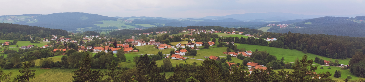
Analysis of the state of preservation, spatial arrangement and tourist usage of residential and garden premises in Janów (silesian voivodeship, Poland)
Corresponding author
DOI: http://dx.doi.org/10.15576/GLL/2021.1.81
The aim of the study is to analyse and evaluate the state of preservation of residential and garden premises and their current use in the Janów commune (Silesian Voivodeship, Poland). The commune, having a huge landscape and natural potential, has at the same time four palace and park premises that are listed in the Registry of Objects of Cultural Heritage. They are located in: Bystrzanowice-Dwór, Czepurka, Złoty Potok and Żuraw. The objects’ history, current state and tourist potential, resulting from their presence in the commune, are presented. Tourism, as a tool of regional policy, facilitates professional insertion of local community. It also influences the region in terms of nature conservation, landscape quality and attention to monuments.
Keywords: Janów • tourism • residential and garden premises • Kraków-Częstochowa Upland
Instructions to authors
The second issue, No. 2 (2021)
Sławomir Tulski ![]() , Kazimierz Bęcek
, Kazimierz Bęcek ![]()
Two methods to mitigate insar-based dems vegetation impenetrability bias
Corresponding author
DOI: http://dx.doi.org/10.15576/GLL/2021.2.7
Digital elevation models (DEM), including the Shuttle Radar Topography Mission (SRTM), are used in many branches of geoscience as an ultimate dataset representing our planet’s surface, making it possible to investigate processes that are shaping our world. The SRTM model exhibits elevation bias or systematic error over forests and vegetated areas due to the microwaves’ peculiar properties that penetrate the vegetation layer to a certain depth. Numerous investigations identifi ed that the penetration depth depends on the forest density and height. In this contribution, two methods are proposed to remove the impact of the vegetation impenetrability eff ect. The first method is founded on the multiple regression of two forest characteristics, namely forest height and forest density. The second method uses a lookup table approach. The lookup table and the multiple regression explanatory variables are taken from the freely available datasets, including the forest density data (MODIS_VCF) and global tree height map (GTHM). An important role in this research is played by the Ice, Clouds, and Land Elevation Satellite (ICESat) data. The accuracy tests indicate that the fi rst method eliminates approximately 68% of the elevation bias, while the second method appears to be more effective, leading to almost complete removal of the vegetation bias from the SRTM data. The methods are fi ne-tuned to the local coniferous forests in Poland. Additional studies are required to fi netune the methods for the leaf-off state of deciduous forests. However, a new set of parameters for both methods can be quickly developed for diff erent locations and forest types. Both methods’ functionality and eff ectiveness can be improved once more accurate forest tree height and vegetation density data become available. These methods are universal in mitigating the vegetation bias from the Synthetic Aperture Radar Interferometry (InSAR) derived model and photogrammetric models.
Keywords: SRTM • vegetation bias • impenetrability • ICESat • GTHM
Tadeusz Gargula ![]()
Point position accuracy in a vector gnss network and the way it is linked to reference stations
Corresponding author
DOI: http://dx.doi.org/10.15576/GLL/2021.2.23
The aim of this study is to assess the impact of the location (distribution) of reference points (reference stations of the ASG-EUPOS system) on the accuracy of the fi nal determination of the local measurement grid points. The research was carried out in terms of the possibility of using the static GNSS method to determine displacements, both relative (vector lengths) and absolute (coordinates in the spatial system). A mathematical record of the computational process (functional model and stochastic model) was presented, on the basis of which the test vector network was adjusted (indirect method) and the accuracy assessment aft er the adjustment was performed. The subject of the numerical tests were the actual measurement results of a part of the geodetic network (GNSS vectors) established in the mining area (the results of one of the periodic measurement cycles were used). Numerical analyses take into account several diff erent variants of establishing the network: depending on the location (direction east–west, north–south) and the number of ASG-EUPOS stations used. The following parameters (relating to the designated positions) were adopted as comparative criteria: coordinate deviation (in the Cartesian geocentric system) from the reference values, spatial length deviation between the designated points from its reference value, mean coordinate errors, error in the position of a point in three-dimensional space, length mean error as a function of adjusted observations (using the law of transfer of errors of mean correlated quantities). Particular attention was paid to the discrepancy between the adjustment results for diff erent systems of reference to the ASG-EUPOS stations. On the basis of the performed calculation tests and the performed comparative analyses, conclusions were compiled that may be helpful in planning periodic measurements for the purpose of determining land displacements.
Keywords: GNSS vector network • establishing a geodetic control network • ASG-EUPOS reference station • rigorous adjustment • determining terrain displacements
Izabela Piech ![]() , Artur Borgiasz
, Artur Borgiasz
The use of UAV data for photogrammetric documentation
Corresponding author
DOI: http://dx.doi.org/10.15576/GLL/2021.2.39
Photogrammetry is a rapidly developing fi eld of science, using new technologies such as unmanned aerial vehicles (UAVs) and digital cameras. Currently, unmanned aerial vehicles are not only used for amateur or professional commemorative aerial photos, but also have much more specialized applications. New technologies allow for faster development of numerous fields of science and provide better results with less work and resources. Unmanned aerial vehicles are used for photogrammetric raids, which produce photogrammetric images of terrain surface or buildings. This allows the generation of orthophotos, and even three-dimensional terrain models, enabling further analysis of a research area. The aim of the study was to make an orthophotomap of the cemetery in the Sułoszowa municipality on the basis of data obtained during a drone raid and to compare it with the existing orthophotomap. The goal was planned to be achieved through the following steps: importing images to Agisoft PhotoScan and georeferencing them to ensure metricity of subsequent studies, generating an orthophotomap and a cloud of points mapping the studied area, compilating and comparing the resulting numerical data, as well as graphic data.
Keywords: UAV • photogrammetric documentation • orthophotomap
Paulina Bidzińska ![]()
Geomorphometry of the physical and geographical microregion of the Polkowice Hills
Corresponding author
DOI: http://dx.doi.org/10.15576/GLL/2021.2.59
In this paper, a morphometric analysis of the terrain sculpture was carried out along with the editing of a geomorphometric map of the physical and geographical microregion of the Polkowickie Hills, which so far was not present in the literature for the studied area. The analysis was performed using the GIS program (ESRI ArcMap), which is based on a digital elevation model (LiDAR ‒ DEM). Following primary topographic parameters were selected through digital elevation model processing: aspect, slope, planar curvature, vertical curvature and local height diff erece, which provide exact information about the variability of the topography and its surface morphological processes. The obtained results of primary parameters allowed for the classifi cation of relief forms in the studied area using the unsupervised ISODATA classifi cation method. The fi nal stage consisted of editing a geomorphometric map of the Polkowickie Hills microregion and a presentation of the distribution of morphometric classes with the height division of boundaries of the obtained geomorphometric separations.
The results of the calculations and analyses allowed for the separation of various areas in the Polkowice Hills, and giving them their own names by the author. The choice of the unsupervised classifi cation method and the independent defi nition of the number of classes gave positive results of terrain clustering of the studied area. The compliance of the results of the selected classifi cation method with the actual topography (of which the author has extensive fi eld and observational knowledge) confi rms the selection of appropriate geomorphometric indicators and the unsupervised classifi cation method, which in the examined case turned out to be computationally eff ective.
Keywords: geomorphometry • geomorphometric indicators • unsupervised classifi cation • Polkowice Hills • geomorphometric map
Zbigniew Muszyński ![]() , Paulina Kujawa
, Paulina Kujawa ![]()
Vertical displacement measurements as an important aspect of education of geodetic surveyors
Corresponding author
DOI: http://dx.doi.org/10.15576/GLL/2021.2.71
The rapid development of industry, the automation of production, processing, and mining processes increasingly put more demands on the scope and accuracy of geodetic surveying. Obtaining precise data on the spatial location of objects involved in the production process is indispensable for the effi cient management of that process. Registered changes in the geometry of objects may indicate potential threats that may adversely aff ect the safe operation of the given object. One of the most diffi cult tasks in engineering surveying is the control of displacements and deformations of building objects and their surroundings. Th is issue is very broad and concerns most industrial facilities, including opencast mines, landslide areas, cooling towers, water dams, as well as securing deep excavations in compact urban development, verticality control of industrial chimneys and wind farms. Each object has its own specifi c features and requires an individual approach in the fi eld of measuring network design, the selection of an appropriate measurement technique, and systematic geodetic monitoring of displacements. The key aspect is the professional experience of the surveyor – the geodesist who is managing this type of work. Already at the stage of educating future engineers, it is important not only to provide them with appropriate theoretical knowledge, but also to enable them to acquire practical skills. For this reason, science camps have been organized since 2013 as part of the process of educating geodesy and cartography students at the Wrocław University of Science and Technology. The thematic scope of the camps includes the measurement of displacements of a unique engineering structure over 50 meters high, which is the fi gure of Christ the King of the Universe, located in Świebodzin. Students gain professional experience using the latest measuring instruments: digital precision levels, motorized electronic total stations, GNSS satellite receivers, and laser scanners. The students, who face real-life surveying challenges, gain valuable professional experiences that improve their qualifi cations and better prepare them for their future work. The article presents science camps as one of the additional forms of educating surveyors. The scope of work performed during the science camp is presented, and the basic measurement techniques are described. Particular attention was paid to the empirical assessment of the accuracy of the results of measurements of vertical displacements performed by students using the precision levelling method. For the measurement data collected over a period of 8 years, the mean levelling errors were calculated on the basis of the analysis of the levelling sections and polygons. The obtained accuracy meets the requirements for measurements performed in order to determine vertical displacements.
Keywords: vertical displacements • precise levelling • empirical accuracy assessment • science camps
Małgorzata Radło-Kulisiewicz ![]()
Review of DTM derivatives most used in digital soil mapping
Corresponding author
DOI: http://dx.doi.org/10.15576/GLL/2021.2.87
Digital Soil Mapping (DSM) is a subdiscipline of pedology, where soil cover is modelled through use of spatial – temporal relations between environmental covariates and soil. The process of quantitative terrain description used in DSM is called terrain parametrization, where terrain attributes (morphometric factors, Digital Terrain Model derivatives) are the most used predicators. Terrain parameterisation was used as a tool in the hydrological survey workshop long before computers had been in use. With the development of digitisation, it also began to be used to determine selected soil attributes, which was greatly facilitated by GIS applications. A signifi – cant breakthrough in the importance of terrain attributes in the creation of soil maps and models took place with the formalisation of rules for digital soil mapping. Literature describes over 50 indices, although only a few of them are commonly applied. This applies to single soil attributes as well as more advanced implementations in more sophisticated models such as artifi cial intelligence algorithms. The aim of the following article is to present the main components of DSM and to describe characteristics of the most commonly derivatives of DTM applied there, also refers to several examples of the use of terrain parameters in the context of DSM in terms of the resolution of the elevation model used.
Keywords: digital soil mapping • DTM • terrain attributes • GIS
Bogusława Kwoczyńska ![]()
Analysis of land use changes in the Tri-City metropolitan area based on the multi-temporal classification of landsat and rapideye imagery
Corresponding author
DOI: http://dx.doi.org/10.15576/GLL/2021.2.101
The aim of the study was to diagnose the main trends of land cover changes around urban agglomerations over the last twenty years (1997–2016) on the example of Tri-City, and to present them statistically and graphically in the form of compilation of numerical maps. The research was performed on the basis of remotely sensed data: LANDSAT 5 TM satellite imagery from 1997 and RapidEye from two records (2011, 2016).
The metropolises of Gdańsk, Gdynia and Sopot, constituting the core of metropolitan area (MA), and municipalities belonging to the Tri-City MA located in its vicinity were selected for detailed analyses – the inner zone of 2 communes and the outer zone, also of 2 communes (MA outskirts). In the selected metropolitan area, communes with good and poor natural conditions for agricultural production were studied.
The analyses were performed on processed images (colour compositions), which were subjected to supervised classifi cation with the maximum likelihood technique. The quality control of supervised classifi cation showed an accuracy of 87.2% for LANDSAT 5 TM scene analyses and 93.8% for RapidEye imagery. The Kappa coeffi cient for the discussed classifi cation was, respectively: 0.85 (LANDSATTM) and 0.93 (RapidEye).
The conducted analyses showed that in the communes there were changes in the way of using arable land and grassland. The greatest changes took place in communes with a low Agricultural Production Space Valuation Ratio (APSVR). Grassland, and to a lesser extent areas with scattered development, replaced arable land. In Gdańsk, Sopot and Gdynia, belonging to the Tri-City, the greatest changes over 20 years took place in arable land, which altogether diminished by 17%, and forest land (13% in total). All this to the benefi t of grassland (increase by 23%) and built-up areas (10% in total in all cities).
Keywords: land use • satellite imagery • metropolitan area
Izabela Piech ![]() , Damian Kowalski
, Damian Kowalski
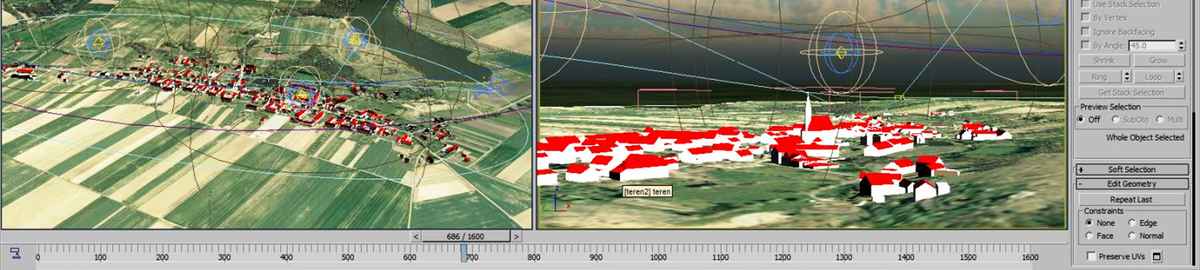
3D visualization of interiors – the case of “U Jaksy” gallery
Corresponding author
DOI: http://dx.doi.org/10.15576/GLL/2021.2.121
Many generations have tried to represent the surrounding space, oft en striving to do so in the most accurate way, precisely refl ecting details and shapes. An important step towards the faithful representation of reality was the creation of photography. Over time, the two-dimensional spatial imaging became insuffi cient, forcing the creator to choose the appropriate perspective and a comprehensive, holistic view of the object. It became possible to recreate the third dimension using two-dimensional photographs, e.g. by creating a stereogram, a panorama, or developing a 3D model. Techniques related to 3D modelling have become a very important element of contemporary photogrammetry, and they allow for an interesting, eff ective, and metrically accurate manner of depicting reality. 3D models can be used for the inventory of objects, for their reconstruction, and for their presentation. Today, there is a great need to represent the world around us in the digital space, starting from selling products whose 3D models make it possible to see that product from every side, to the creation of three-dimensional maps with street views, such as Google street view, to creating virtual city and museum walks. The products of 3D graphics are not only used for visual eff ects. The models’ metric accuracy also enables numerous engineering applications. Among other things, 3D models can be used in geodesy for inventory measurements, they fi nd their application in architecture and spatial planning, as well as in many other engineering activities related to the designing of parts, machines, and objects.
Keywords: non-metric cameras • 3D models • visualization
Instructions to authors
The third issue, No. 3 (2021)
Bogusława Kwoczyńska ![]()
Determining the volume of soil masses using different measurement techniques
Corresponding author
DOI: http://dx.doi.org/10.15576/GLL/2021.3.7
Calculating the volume for various types of surfaces and materials is important for many branches of engineering sciences. Correct volume calculation often has a significant impact on the cost and time of a given project. These type of calculations are already applied at the design level. Measurement of cubature is crucial, for example, in construction and mining.
The paper presents an analysis of and calculation results for measuring the volume of soil masses using different measurement techniques, which include: LIDAR (in this case of terrestrial and airborne laser scanning), photos taken with the use of UAV and measurements in the GNSS method. The object of the study was an earth mound located in the Park Dębnicki in Kraków. Relative volume error has been calculated in relation to the terrestrial laser scanning (TLS) method. For each of the tested methods, the error remained within the limits allowed by the standards and amounted to 0.2% for airborne laser scanning (ALS), 2.3% for photos obtained from UAVs and 3.4% for the GNNS-RTK method. The results of tests are presented in graphic and tabular forms. The obtained results were compared and the most advantageous measurement techniques to be used in determining the cubic capacity of this particular research object was indicated.
Keywords: volume • soil mass • LIDAR • UAV
Andrzej Kwinta ![]() , Joanna Bac-Bronowicz
, Joanna Bac-Bronowicz ![]()
Analysis of hyperboloid cooling tower projection on 2D shape
Corresponding author
DOI: http://dx.doi.org/10.15576/GLL/2021.3.25
This paper undertakes the problem of mapping a hyperboloid cooling tower on a single plane. Measurements performed by ground-based laser scanning technology quickly deliver substantial amounts of geometric data of the tower’s outer wall. The essence of the article is projection of the rotational hyperboloid on a plane. The shape of the hyperboloid cooling tower is not directly expandable to a single plane. Mapping a hyperboloid shape on a plane is, therefore, associated with distortions. This paper presents a comparison between cylindrical and conic projection of a hyperboloid cooling tower. The most popular method of mapping hyperboloid is cylindrical projection. The cylinder’s side surface is easily developed on the drawing sheet. For the hyperboloid cooling tower, the biggest distortions occur in the latitudinal direction and reach the highest values at the top and bottom edges. The equation (13) describe distortion for the cylindrical projection. The equation (18) describe distortion for the conical projection. This paper presents results obtained from the performed measurement. The analysis found that cone mapping produces less distortion than cylindrical projection for the hyperboloid cooling tower. We think, that in conical projection, the shape of a hyperboloid cooling tower and theoretical conic shape have better corresponding together than in cylindrical projection.
Keywords: hyperboloid cooling tower • tower measurement and analysis • cartographic projection • laser scanning
Paweł Pieńkowski ![]() , Marcin Stoltman
, Marcin Stoltman ![]() , Bogusław Zakrzewski
, Bogusław Zakrzewski ![]()
Location of overhead power lines within Bukowe hills mesoregion in relation to the assessment of forest area fragmentation
Corresponding author
DOI: http://dx.doi.org/10.15576/GLL/2021.3.41
National power grid in Poland requires modernisation, therefore by 2030 numerous actions are scheduled regarding the expansion of the existing network and the construction of new electricity transmission lines (power lines). The planned activities will undoubtedly change the quality of landscape and result in fragmentation of forest habitats, some of which are characterised by high biodiversity and constitute a key element of ecological corridors. The aim of the present paper was to outline the issue of the impact of the power line corridors on forest habitat fragmentation, as well as to present the GuidosToolbox software (Graphical User Interface for the Description of image Objects and their Shapes) used, among other things, for the determination of the degree of fragmentation of forest habitats. The analysis concerned the Puszcza Bukowa forest, which is a part of the Natura 2000 network and is protected under the Szczecin Landscape Park ‘Puszcza Bukowa’. Despite abundant natural assets of the Puszcza Bukowa forest, it was necessary to run many power lines through its area due to location of the forest in the vicinity of the Szczecin agglomeration. The course of power lines contributed to the fragmentation of the discussed forest complex and to the depletion of its interior classified with the GuidosToolbox software as ‘Intact’. The software discussed in the present paper may prove useful in the identification of the degree of forest area fragmentation, connected with the course of high-voltage power transmission lines, and in the assessment of the impact of the planned investment projects on biocenoses.
Keywords: high-voltage power transmission lines • habitat fragmentation • landscape fragmentation • landscape analysis
Izabela Piech ![]() , Przemysław Klapa
, Przemysław Klapa ![]() , Piotr Szatan
, Piotr Szatan
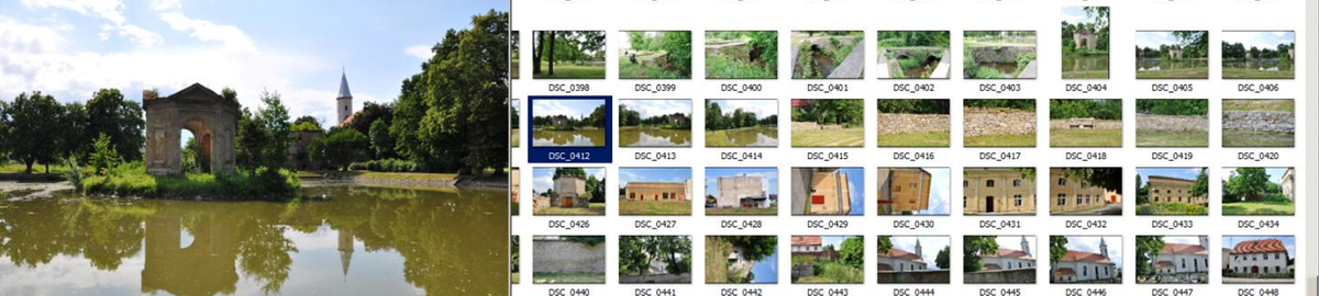
The use of terrestrial laser scanning in the preservation of valuable architectural objects
Corresponding author
DOI: http://dx.doi.org/10.15576/GLL/2021.3.53
In the present day, we are witnessing the dynamic development of our country. We observe a growing number of new construction investments, which are designed to meet the needs of the market. Streets are being widened to cope with the growing number of vehicles, modern office buildings and skyscrapers are being built in the largest Polish cities, which at the same time have valuable architectural objects in their oldest districts. Such objects, due to their age, are susceptible to damage, and thus to the threat that their value will be lost. Such damage may occur in the course of construction works that destabilize the soil structure, which may lead to damage to the building’s foundations and, as a result, harm or destroy the most important structural elements of the monument. Another important factor is the operation of industrial plants that emit harmful substances, which have a negative impact on façades and other external elements, such as, for example, relief sculptures. It may be difficult and complicated to remove the effects of the risks described above if the documentation necessary to carry out protection or renovation works is incomplete or insufficiently detailed. A separate issue worth discussing are architectural objects made of perishable materials such as wood [Bernat et al. 2014]. There are many objects of wooden architecture in Poland, such as: Catholic and Orthodox churches, open-air museums, and other relics of bygone eras. Apart from the obvious threat of fire and its negative effects, one can also mention the negative impact of precipitation, whether in the form of rain causing the wood to soak and, as a result, to rot, or the risk of damaging the foundations during a flood. The listed threats have a direct and indirect impact on the structure of such historical buildings. Therefore, it is important to take care of their detailed survey, with the view to preserving and maintaining them. It is also worth mentioning a large number of castles located in our country. The condition of their structures is very diverse and ranges from newly restored buildings to those with only foundations left. In all cases, it is important to obtain accurate plans and models of these building objects. This will serve to preserve their dimensions and shapes. Such data can be used to develop documentation necessary to carry out reconstruction or renovation in order to return the building to its former glory, and thus obtain another object worth seeing.
Keywords: terrestrial laser scanning • survey • architecture
Izabela Piech ![]() , Mateusz Kopciara
, Mateusz Kopciara
Modernization of buildings in a specific area, using photogrammetric methods
Corresponding author
DOI: http://dx.doi.org/10.15576/GLL/2021.3.65
Photogrammetry is a rapidly developing field of science, using new technologies such as unmanned aerial vehicles (UAVs), and digital cameras. This field deals with obtaining reliable information about physical objects and their surroundings by means of recording, measuring and interpreting images [Markiewicz et al. 2012]. Currently, unmanned aerial vehicles are used not only for taking amateur or professional commemorative aerial photographs, but they also find much more specialized applications. Among these applications, we can distinguish air pollution inspections (carried out, among others, by municipal police), border inspections, search for missing persons, and many other uses [Nowobilski 2020]. UAV photogrammetry can be understood as a new photogrammetric measurement tool. It opens up various new applications in the field of short-range imaging, combining aerial and ground photogrammetry; and it also introduces low-cost alternatives to classical aerial photogrammetry with crew [Eisenbeiß 2009]. Today, not everyone can afford photogrammetric flight campaigns, which require more time and money. Although UAVs are not used on a large scale in surveying, still, their development, the possibility of using them for surveying works, the accessibility and ease of application, as well as the development of the cameras themselves, convince more and more surveyors to use them more broadly in the performance of geodetic works.
Unmanned aerial vehicles are used to perform photogrammetric mission flights, thanks to which photos of the land surface are obtained. This allows for the generation of orthophotos, and even three-dimensional terrain models, enabling further analysis of the studied area. The aim of this study was to present the possibility of using UAVs for the purpose of updating land and buildings records in a specific area. Based on the photos obtained during the photogrammetric mission, an orthophotomap had been generated, which was subsequently used for the modernisation of records and updating the functions of buildings and areas. Then, all the buildings on the land plots were grouped according to their function, status, construction material, number of storeys, and area calculated from the roof surface. 37 land plots were covered by the measurement. 5 selected plots were used for the purpose of this publication.
Keywords: UAV • drone • photogrammetry • orthophotomap • land and building records
Szczepan Budkowski
Problem of soil science based cLassification of land in the context of updating land and building records
Corresponding author
DOI: http://dx.doi.org/10.15576/GLL/2021.3.83
Pursuant to the Geodetic and Cartographic Law, the soil science based classification of land should be understood as the division of soils into valuation classes due to their productive quality, determined on the basis of soil genetic features. Pursuant to the above-mentioned Act, the task of the starosta (district administrator) is to maintain both the soil science classification of land, and the land and building records (cadastral records). The data that is the subject of the decision issued by the authority in the field of soil science classification of land constitute elements of the essential information set within land and building records, in accordance with Article 23 section 3 point 1 g of the Geodetic and Cartographic Law [PGiK]. The aim of this publication was to present the irregularities resulting from the failure to update land and building records, as well as from the lack of uniform administrative procedures in the field of soil science classification of land, which translates into the quality of the works performed. The research method used is the case study. The method was supported by the analysis of legislation in the above-mentioned subject matter.
Keywords: land and building records • soil science based classification of land • law • classifier • space
Joanna Gronkowska
Energy cluster – an attempt in characterisation and definition
Corresponding author
DOI: http://dx.doi.org/10.15576/GLL/2021.3.93
Clusters are an organisational and economic phenomenon. This paper attempts to answer what an energy cluster actually is and whether it meets the requirements of a cluster in the classical approach of economic sciences.
The Act of 20 February 2015 on renewable energy sources (Ustawa OZE 2015) introduced the concept of an ‘energy cluster’. It was aimed at, among others, increasing energy security and environmental protection through an efficient use of renewable energy sources. In the literature on the subject, there is no single universally applicable definition of a cluster, it can only be considered in its various aspects. The concept of a cluster has so many applications, associations and meanings that in many respects it has become a ‘chaotic idea’ due to flattening and equalising different types, processes and spatial scales of economic location within one universal concept. However, the main doubt concerns the very definition of a cluster.
Keywords: energy cluster • network structure • cooperation • business alliance
Instructions to authors
The fourth issue, No. 4 (2021)
Ousseni Arouna ![]() , Dramane Issiako
, Dramane Issiako ![]() , Briac Kévin Patrick Kossougbeto
, Briac Kévin Patrick Kossougbeto ![]()
Applcation of geomatics to the multicriteria zoning of the Upper ALibori forest reserve in northern benin (West Africa)
Corresponding author
DOI: http://dx.doi.org/10.15576/GLL/2021.4.7
The Forest of Upper Alibori is subject to strong agricultural and pastoral pressures from year to year despite the implementation of a forest management plan. It is therefore appropriate to conduct an integrated and spatialized analysis of the effects of these pressures on plant biodiversity from a spatial planning perspective. The research objective is to establish a multi-criteria zoning of the Upper Alibori Forest Reserve that can reconcile biodiversity conservation and sustainable agropastoral exploitation. A methodological approach based on geomatics was adopted. Hierarchical multi-criteria analysis and cross-layer analysis are the main techniques adopted. The state of plant biodiversity, one of the important criteria for multi-criteria zoning. The intersection of the scientific zoning and the zoning proposed by the riparian population shows a similarity of 54%. In the central core, the similarity between the two types of zoning is 32%. Spatially, this similarity is observed along the Alibori River. At the level of the agricultural series, the two zonings show a similarity level of 23%. The elaboration of an integrated zoning made it possible to distinguish several management series. The management series delimited are made up of the central core (32%), the protection series (11%), the production series (17%), the scientific research series (2%), the service series (2%) and the agropastoral and reforestation series (36%). The implementation of such zoning is the responsibility of the forest administration.
Keywords: pressures • biodiversity • geomatics • management • Upper Alibori forest reserve • Benin
Asma Menasra ![]() , Soumia Bouzaher
, Soumia Bouzaher
GIS tools for landscape character assessment: case of Ziban region in Algeria
Corresponding author
DOI: http://dx.doi.org/10.15576/Gll/2021.4.19
Landscape is an area formed by the interactions between humans and nature, which bring various characteristics to the area. Landscape Character Assessment (LCA) methods enable more accurate description, mapping, and evaluation of features within the landscape. Also, landscape characterization and classification is facilitated by the advances of Geographic Information Systems (GIS), which constitute a very efficient tool for analysis and overlay mapping. This paper explores and tests an application of Landscape Character Assessment (LCA) methodology at a regional scale in Ziban region, Algeria, combining natural and cultural attributes using GIS. The first stage of overlay of attributes is followed by the verification of draft map involving a visual assessment on-site in order to develop the final classification and assessment describing each landscape character area and type. The study results show that Ziban region has a rich structure with diversified landscapes created by unique natural and cultural landscape values composed of 36 different character areas and 19-character types. The main contribution of this research consists in developing a typology for Ziban landscape and providing useful results for decision-making related to the future management of landscape character in the Algerian context, which has undergone strong pressure related to urbanization, industry, transport, desertification, and tourism.
Keywords: Geographic Information Systems (GIS) • landscape character assessment • landscape • Ziban region • landscape character types • landscape character areas
Asma Douha ![]() , Mahdi Kalla
, Mahdi Kalla ![]()
Analysis and modelling of territorial vulnerability to epidemiological diseases in the Wilaya of batna (Algeria) – case of tuberculosis
Corresponding author
DOI: http://dx.doi.org/10.15576/GLL/2021.4.31
Some epidemiological situations, because of their magnitude and their propagation dynamics, can escape local or national control. For example, the world is currently experiencing an uncontrollable cross-border spread of the corona virus (Covid-19). The Wilaya of Batna is among the most affected in Algeria by many epidemiological diseases, including tuberculosis, which raises questions about possible causal links between this contagious and often fatal disease and the environmental and socio-economic reality of this territory. We based our study on a number of factors, covering economic, societal and health aspects, which constitute indicators of the standard of living in each of the 61 communes of the Wilaya of Batna. The relationship between the epidemiological status of tuberculosis in these communes and these indicators showed significant correlations and thus confirmed the reliability of the choice of parameters of vulnerability to tuberculosis. To understand their interaction and impact on the disease and its spatial distribution, we used the hierarchical multicriteria analysis (AHP) method, the results of which were implemented in a GIS database. The aim was to provide health and territorial decision makers with a decision support tool. The results show that the spatial distribution of tuberculosis cases which reappeared in the Wilaya of Batna after its eradication since years is in good correlation with the socio-economic situation of each commune of the territory and confirm that this scourge of tuberculosis is closely linked to the degradation of the living conditions of the inhabitants.
Keywords: GIS • AHP • tuberculosis • environment • Batna• vulnerability
Issues of the profession of a land classifier
Corresponding author
DOI: http://dx.doi.org/10.15576/GLL/2021.4.47
From the legal point of view, the soil science classification is regulated by the Geodetic and Cartographic Law, where it is defined as the division of soils into valuation classes due to their production quality determined on the basis of the genetic characteristics of the soil. The executive act regulating the issue of soil science classification of land are the provisions included in the Regulation of the Council of Ministers of September 12, 2012 on soil science classification of land (Journal of Laws 2012, item 1246). The aim of the article was to present the problems resulting from the lack of regulation of the profession of land classifier and the lack of uniform administrative procedures regarding the selection of the classifier for the purposes of the classifications. The research method used is the case study. The method was supported by the analysis of legislation in the above-mentioned scope.
Keywords: land and building register • soil science classification • law • classifier • space
Izabela Piech ![]() , Wioletta Szyszka
, Wioletta Szyszka
Synergy of photogrametric data obtained based on terrestrial photos and UAV images
Corresponding author
DOI: http://dx.doi.org/10.15576/GLL/2021.4.55
Methods of short-range digital photogrammetry and unmanned aerial vehicle imagining increasingly find more extensive usage in various types of measurements. In recent years, modern photogrammetric technologies have found wide application in recreating 3D models of any objects. The resulting 3D models can be a source of information that may be used for measurement, inventorying and cataloguing, as well as for visualisation purposes.
New methods of acquiring spatial data have been developed, such as laser scanning, imaging using unmanned aerial vehicles or digital non-metric cameras. Synergy and the confluence of these data have expanded the existing measurement possibilities, finding application in 3D modelling, inventorying of monuments, or monument conservation. Photogrammetric methods are comparable to direct measurement methods in terms of their accuracy, as well as speed and cost. They have a number of advantages, including a shortened time required for taking a photo, which is greatly convenient when measuring moving objects. Other advantages of photogrammetric methods include the possibility of development and performing measurements in chamber conditions and the lack of restrictions pertaining to repeating the measurement when errors are found or a need arises to supplement them [Kurczyński and Preuss 2000]. One of the possibilities offered by photogrammetry is the ability to create 3D visualizations. The creation of a three-dimensional model facilitates presenting the inventoried object in a realistic, complete, and up-to-date manner. This paper presents an attempt to synergise data for modelling a three-dimensional architectural object based on photos obtained with the Nikon D7500 non-metric camera and with the DJI Mavic Air unmanned aerial vehicle.
Keywords: synergy • 3D models • non-metric cameras • unmanned aerial vehicles
Data classification to improve the algorithm for assessing an external patchwork of land ownership
Corresponding author
DOI: http://dx.doi.org/10.15576/GLL/2021.4.75
Research conducted for many years in Poland and around the world has demonstrated that defects in the spatial structure of agricultural land resulting from the common phenomenon of land fragmentation constitute one of important factors that contribute to the lack of rational land management. Reconstruction of the spatial structure of rural areas is essential for sustainable development of these areas. The process of land consolidation and exchange is a tool that can arrange space and lead to the desired structural changes, however, it has to be performed systematically and primarily in those areas where it is most urgently needed. With limited budget resources, it is reasonable to select objects for land consolidation in such a way as to obtain the best possible effect. In case of a selected group of neighbouring villages, a joint land consolidation procedure will enable better consolidation effects, inter alia by eliminating the external patchwork of land ownership. This article describes the modification and improvement in the methodology of designating areas with concentration of the external patchwork of land ownership. It is based on Czekanowski’s diagram and was originally presented in 2017. The applied classification of numerical data enables the elimination of undesirable numerical effects of calculations and simplifies the interpretation of the final results.
Keywords: rural areas • spatial analysis • land fragmentation • land consolidation • data classification • plot patchwork
A study on the maintenance of spatial order in the development perspectives of the city of Nowy Targ
Corresponding author
DOI: http://dx.doi.org/10.15576/GLL/2021.4.87
The study aims to analyse the functioning of the city of Nowy Targ in the context of maintaining the principles of spatial order. The concept of spatial order is used not only by city planners, but also by other representatives of sciences related to spatial management. Spatial order is an interdisciplinary concept as it appears in many fields of sciences, not only technical ones. Inextricably linked to the idea of sustainable development, spatial order combines issues from urban planning, architecture, economy, and environmental protection. It can be considered in relation to several categories, such as: conscious space design, development of appropriate spatial patterns, protection of characteristic spatial systems, shaping space in accordance with tradition and culture, and counteracting spatial disharmony trends. This study begins by discussing various definitions of spatial order found in the literature. A study on the maintenance of the principles of spatial order in Nowy Targ covered a range of factors from the socio-economic, functional, cultural, environmental to compositional and aesthetic. While developing such a topic it is important to verify the stages of implementation of the assumptions of source documentation, like the ‘Nowy Targ City Development Strategy for 2019‒2023 with an outlook to 2030’. The following research tools were used in the study: Desk Research (a review of publicly available data, including a study of legal regulations and a review of the literature on the subject) and CAWI (Computer Assisted Web Interviews – an online survey addressed to a wider audience).
The results of the analyses showed Nowy Targ’s significant potential for the implementation of spatial order principles and high social awareness of the need to respect them by its inhabitants.
Keywords: spatial order • city development • sustainable development
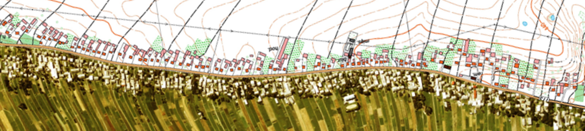
Spatial entropy changes for built-up areas in the vicinity of Kraków in the years 2014–2020
Corresponding author
DOI: http://dx.doi.org/10.15576/GLL/2021.4.103
Information on landscape structure is an important issue for sustainable development and for making correct spatial planning decisions. Therefore, studies providing information on the diversity and changes of land cover and land use in a selected area are currently an important research topic. In addition to quantitative-qualitative statistics, spatial entropy is increasingly used to assess the degree of diversity of land cover and land use. This paper aim was to determine the diversity of objects within the land cover classes in the years 2014, 2017 and 2020, with a focus on built-up areas, in three districts bordering the city of Kraków, i.e. the Wieliczka, Kraków and Proszowice districts, located in the Małopolskie Voivodeship in Poland. In order to perform the analysis with the appropriate spatial resolution, a hex grid was used to determine the diversity of objects in the built-up area class. For this reason, data on land cover from the BDOT10k national database of topographic objects were used. The analyses followed the division into classes and objects defined in the structure of the BDOT10k database. The degree of diversity was determined using the Entropy Index and Herfindahl-Hirschman Index. Changes in the diversity of built-up areas were observed especially in areas located in close proximity to the border of Kraków, as well as on its eastern and south-eastern sides. A significant relationship was also observed between the increase in diversity of objects in the built-up area class and the immediate proximity of roads.
Keywords: built-up areas • BDOT10k • entropy • land cover • hexagons
, Pelagia Gawronek Accuracy of the BIM model generated from the point cloud for an object made in glass technology
Corresponding author
DOI: http://dx.doi.org/10.15576/GLL/2021.4.117
Mapping glass objects in 3D space has long raised doubts as to the possibility of obtaining data, and as to the accuracy of that data. The basics of terrestrial laser scanning technology and the principles of the physics of light propagation in the environment of transparent and reflective surfaces, as a rule, contradict the technological possibility of a faithful mapping thereof. Although Building Information Modelling (BIM) of existing objects based on data from terrestrial laser scanning is an increasingly common practice, it is recognized, nevertheless, that the accuracy of the model is primarily reflected in the accuracy of the point cloud obtained as a result of scanning. The article discusses the possibilities of developing a BIM model of an object made in glass technology, based on data obtained with the method of terrestrial laser scanning. The subject of the study was the glazed façade of the complex of buildings belonging to the University of Agriculture in Krakow. The study on the fidelity of mapping glazed surfaces included the acquisition and processing of the point cloud, 3D modelling of the object using the Revit software, and the analysis of the accuracy of mapping the existing status in comparison with architectural design and construction documentation. Based on the research, the possibility of using the BIM process was assessed using TLS data in the process of recreating the geometry of an object made in glass technology. The results of the study showed a significant convergence of the façade model geometry with the actual course of the structure, which, however, can be attributed to the development methodology, i.e. the accuracy of 3D data acquisition, the registration process, the filtration procedure, the method of parametric modelling of the façade structure itself, and ultimately fitting three-layer glazing into the model of that structure.
Keywords: terrestrial laser scanning • architectural survey • modelling • glass façade • accuracy analysis of geometry modelling
An attempt to assess the impact of securities on the stable and safe operation of cooperative banks in Poland
Corresponding author
DOI: http://dx.doi.org/10.15576/GLL/2021.4.135
Over the past 10 years, cooperative banks in Poland have significantly increased their share and changed the structure of financial instruments in their portfolio. Asset structure is key to both performance and risk resilience. There can be various reasons for increasing the share of non-credit current assets, including regulatory requirements, the need for revenues diversification or effective liquidity management, and the effects of such decisions depend on various factors, whether macroeconomic, sectoral or individual. The paper aims to assess the role of securities for the stable and safe operation of cooperative banks in Poland and to try to answer the question of whether these relations are similar to those in the commercial banking sector. The theoretical part of the paper includes a short definition overview related to the studied problem, i.e. identification of concepts related to the safety and stability of banks, financial instruments and the specificity of cooperative banks. In addition, an analysis was made of the regularities that can be encountered when shaping the optimal structure of assets in banks. To verify the research hypothesis about the positive impact of financial instruments on the stability of cooperative banks, a linear regression model was used. For measuring the stability the Z-Score indicator was adopted. The research period covered annualised monthly data for the period 12.2010–09.2021. Obtained results confirm the importance of the role played by financial instruments in building cooperative banks’ stability. The increase in the level of financial instruments had a beneficial effect on bank stability, but only when it took place in a smooth manner and, in addition, when their share in the asset structure was small.
Keywords: financial instruments • security • stability • Z-Score • cooperative banks
Robust vegetation detection using RGB colour composites and isoclust classification of the Landsat TM image
Corresponding author
DOI: http://dx.doi.org/10.15576/GLL/2021.4.147
The paper presents the application of ArcGIS for environmental modelling of the landscapes in northern Iceland (17.00°W–23.00°W, 64.30°N–67.00°N). The aim was to explore the vegetation distribution by NDVI and ISOCLUST classification of the land cover types. Data include the Landsat TM image. Freely available satellite remote sensing data from the Landsat mission have been processed by GIS to deliver information on land cover types from image classification and NDVI vegetation index. Landsat products provide geospatial data on regional scale with moderate temporal (weekly) and spatial (30–10 m) resolution, making them useful for environmental monitoring and landscape studies. The tools include the ArcGIS software used for raster processing. Data processing was performed in the three steps: 1) comparative analysis of the visualized sixteen band combinations to assess the distinguishability of vegetation and other land cover types in colour composites; 2) computed NDVI standardized vegetation index; 3) unsupervised classification of the Landsat TM by the ISOCLUST algorithm. Large glaciers Hofsjökull and Langjökull were detected on various colour composites, and the visibility of the water/land borders is assessed (Blöndulón lake), agricultural areas near the Varmahlíð, vegetated areas around the Akrahreppur municipality. Computing the NDVI and using ISOCLUST by ArcGIS software enabled to distinguish various land cover types and map landscapes in the study area. The computed NDVI shown the presence and condition of vegetation, that is, a relative biomass in the area of northern Iceland. The NDVI was used based on the contrast of the two channels from a multispectral Landsat TM raster data.
Keywords: cartography • Iceland • remote sensing • Arctic • ArcGIS • mapping
Analysis of the geometry of the TPI NETpro reference station network in Poland
Corresponding author
DOI: http://dx.doi.org/10.15576/GLL/2021.4.169
Active geodetic networks currently perform many important tasks, including supporting satellite measurements with relative methods (e,g. Real Time Kinematic, Network Real Time Kinematic). For this reason, the geometries of reference station networks should meet certain standards both in terms of optimal distances between the reference stations as well as their spatial distribution. The paper presents a spatial analysis of the TPI NETpro commercial active geodetic network and a comparison of the obtained geometric parameters with the values calculated in relation to the national ASG-EUPOS network. Voronoi polygonization (also known as Dirichlet tessellation) and Delaunay triangulation were applied to assess the geometric dependence of the location of reference stations, while the nearest neighbour analysis was used to determine the degree of clustering of reference stations. The conducted analyses showed that the analysed network of TPI NETpro reference stations is characterised by a geometry similar to the national network ASG-EUPOS. The average distance between the neighbouring stations of the TPI NETpro network, expressed as the average length of the sides of Delaunay triangles built on this network, is 64.93 km, while the analysis of the nearest neighbour showed an average distance between stations of 41.97 km. The average distance connecting the TPI NETpro network points with the nearest neighbour from the ASG-EUPOS network is 25.20 km, and 41.06 km in the case of the three nearest neighbours. It has also been demonstrated that the ASG-EUPOS network points are more dispersed than the TPI NETpro network points.
Keywords: active geodetic network • TPI NETpro • ASG-EUPOS • Voronoi polygons • Delaunay triangulation
Owner of the Journal
University of Agriculture in Krakow
Faculty of Environmental Engineering and Land Surveying
Balicka st., no. 253a, 30-198 Krakow, Poland
phone: +48 12 662 45 32, fax +48 12 662 45 03
e-mail: gll@urk.edu.pl
Publisher
Publishing House of the University of Agriculture in Krakow
29 Listopada av., no 46, 31-425 Kraków, Poland
phone: +48 12 662 51 51, fax +48 12 662 51 59
e-mail: wydawnictwo@urk.edu.pl
e-mail: iwona.pisiewicz@urk.edu.pl